

Barker Dam and Reservoir in Houston on Tuesday, Sept. 19, 2017 (Michael Stravato/The Texas Tribune)
When Jeremy Boutor moved to a master-planned community in Houston’s booming energy corridor, he saw it as idyllic.
Lakes on Eldridge boasted waterfalls, jogging trails and a clubhouse. It was upscale, secure and close to the office. A bus even picked up his two young sons in front of their house and took them to a nearby international school.
“This neighborhood was a paradise,” said Boutor, who moved to Houston from Paris two years ago after his employer, a French-based energy company, asked him to relocate.
Then, Hurricane Harvey changed everything.
As the downpours began and Boutor studied maps flashing on his TV screen, he realized that his home wasn’t at risk of flooding just because of record rainfall; it was also located inside one of two massive reservoirs that had been built west of Houston decades ago to protect the city.
Boutor ended up with more than a foot of water in his house and was forced to wade out of his home in knee-deep water with his 10-year-old son clinging to his back.
He and his neighbors are now coming to terms with the fact that in big enough rainstorms, their neighborhoods are actually designed to flood. And nobody told them about it.
When the U.S. Army Corps of Engineers built the two reservoirs known as Addicks and Barker on what was then mostly empty prairie, their chief goal was to protect the center of the city, 20 miles downstream.
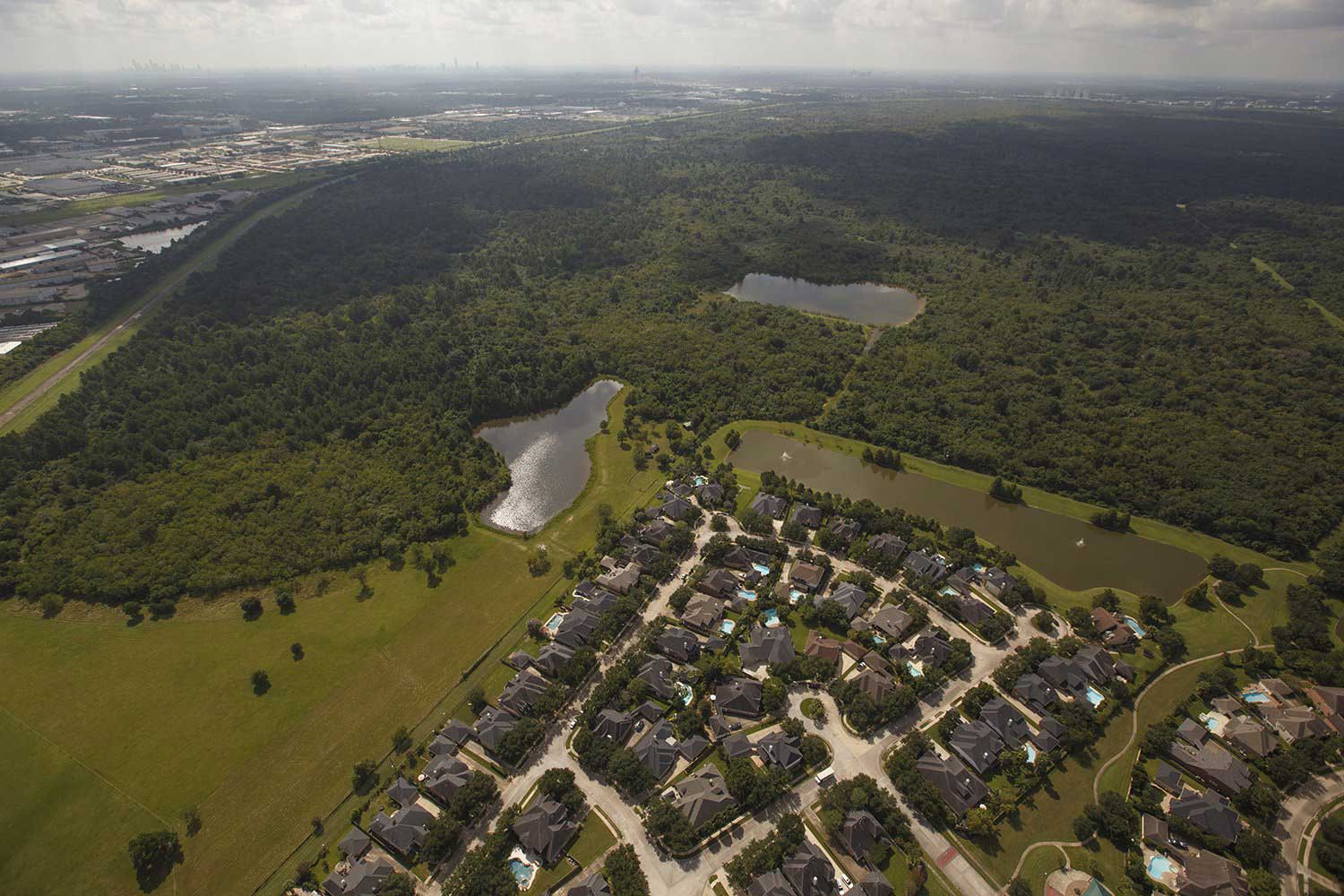
The vast basins are dry most of the time, dotted with wooded parks and sports fields, and are contained on their western boundaries by large, earthen dams. During rainstorms, floodwater accumulates behind those dams in areas known as “flood pools” and backs up to the east; how far it goes depends on how big the rainstorm is and where it hits.
That system worked well when the reservoirs were surrounded by prairie and rice fields. But in recent decades, development has encroached from all sides. Today, about 14,000 homes are located inside them. During Harvey, when more floodwater accumulated behind the dams than ever before, 5,138 of those homes flooded.
Some local government officials, like Harris County Commissioner Steve Radack, say they’ve warned residents for years about the risks of living in or around the reservoirs during town halls and other public events.
“It is very difficult to make people believe the unbelievable,” Radack said. “No one ever believed the reservoirs would fill.”
Harris County Judge Ed Emmett, the county’s top elected official, said residents must know they live in the reservoirs — the dams, he said, are right there.
“You’ve got a group that bought homes if not in, then on the very edge of reservoirs behind the dams, so that’s pretty obvious,” Emmett said.
But it’s clear after Harvey that it wasn’t obvious to a lot of people. None of the more than half a dozen residents interviewed by The Texas Tribune and ProPublica after the floods say they knew they were living inside Addicks or Barker — many of their neighborhoods are several miles away from the dams.
Several local officials — including Houston’s “flood czar” and a neighboring county executive — said they had no idea the neighborhoods had been built inside the flood pools. Several real estate agents said they didn’t realize they were selling homes inside the pools.
“When I started to rent this house, nobody told me,” Boutor said. “Even the insurance company told me that it was not a flooding area.”
But critics say those officials and developers had to know they were putting people and property at risk.
“They had full knowledge. They knew exactly what they were doing,” said Phil Bedient, a professor of engineering at Rice University who studies flooding in the Houston area. “It’s a huge geopolitical mistake. How are they going to fix it?”
The question of who’s to blame has reignited long-simmering tensions between Harris County and the city of Houston.
In recent interviews, Emmett, the county judge, claimed that the city regulates development inside the reservoirs. But the city’s “flood czar,” Stephen Costello, called that “outrageous” and said the county plays a role, too.
Ultimately, all of them blame Congress. For more than a decade, the U.S. Army Corps of Engineers has identified a number of major needs for Addicks and Barker — including a comprehensive study of how development affects the reservoirs — but hasn’t gotten enough funding to address all the issues.
No matter whose fault it is, Fort Bend County Judge Robert Hebert — who has a portion of Barker Reservoir in his jurisdiction — said “you can’t take all that developed property off that land. It’s there. Whether it should have been allowed to be built the way it did … that wasn’t on my watch.”
But now that the homes and streets are there — instead of the prairieland that used to absorb rainwater — scientists, along with Harris County and federal officials, say they are sending more runoff into the reservoirs during heavy storms. That means the reservoirs are getting fuller with each big rain event, threatening not just neighborhoods inside the reservoirs but the integrity of the earthen dams, too. The dams have been considered at risk of failure for years.
As Addicks and Barker reached historic levels during Harvey, the Army Corps sent an unprecedented torrent of floodwater downstream to ease the stress on dams. That caused thousands of additional homes to flood — homes that the reservoirs were initially built to protect.
Ed Taravella, a longtime Houston developer, said he hasn’t seen any credible studies showing that development has sent more runoff into the reservoirs. “Things people say are largely anecdotal,” he said.
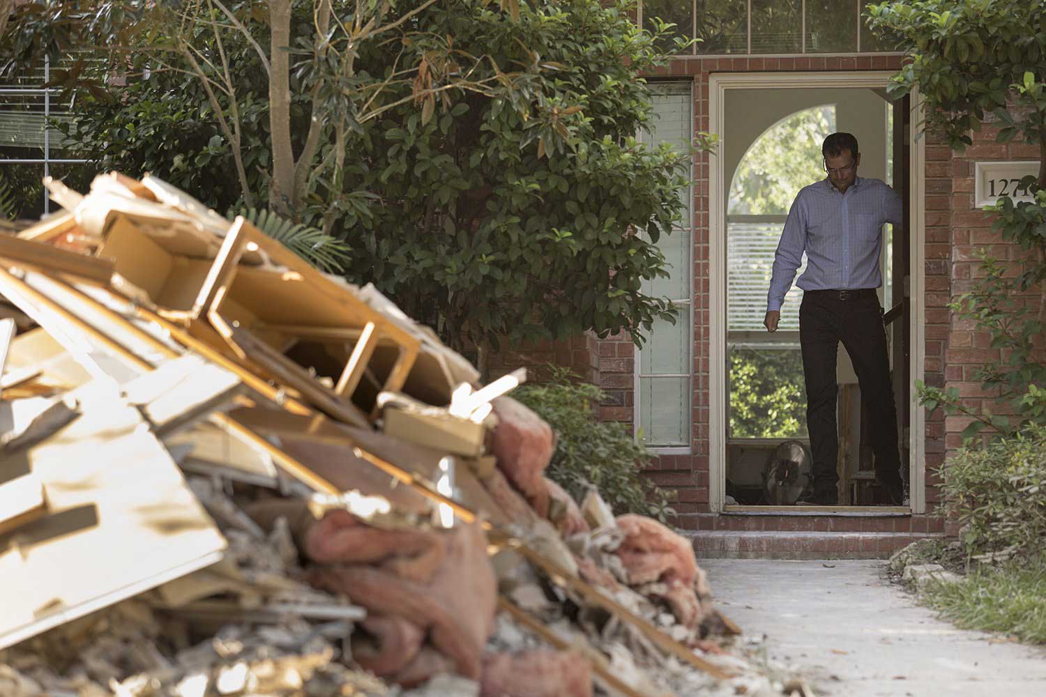
Jeremy Boutor at his flood-damaged rental home in one of the neighborhoods flooded in Addicks Reservoir in Houston on Tuesday, Sept. 12, 2017. (Michael Stravato/The Texas Tribune)
But scientists say the impact of replacing prairie with pavement is clear: More water ends up in the reservoirs, rather than being absorbed into the ground. The Army Corps has said as much for years.
“As development continues, we’re going to see more water coming to the reservoirs,” Richard Long, who oversees Addicks and Barker for the agency, told The Texas Tribune and ProPublica last year. “It means we have a harder job to do.”
Long added that the Army Corps doesn’t have the power to control development on land the agency doesn’t own.
“That would require the act of politicians, and they’ve chosen not to do it,” Long said.
For at least six years, the Army Corps has sought $3 million to study the risks that development poses to the reservoirs, but Congress hasn’t approved it — and no local government agreed to sponsor the study until recently. Last week, Texas officials asked Congress to provide $10 billion for a variety of Army Corps projects as part of Harvey recovery efforts.
The Army Corps is now referring media inquiries to the U.S. Department of Justice as it faces mounting lawsuits from residents who live upstream and downstream of the reservoirs. Some also are suing the city and county.
Local officials like Hebert said they never considered the possibility that the reservoirs would hold so much water — until Harvey set national records by dropping up to 50 inches of rain in parts of southeast Texas.
“To be perfectly honest with you, nobody had ever discussed with me the risk of inundation to the degree we had,” he said. “I was vaguely aware that if we got high enough, we could get water in those streets … It was just something that was incomprehensible.”
He said he still considers it a “unique event” and doesn’t think it’s likely those homes will flood again any time soon.
Before Harvey, the neighborhoods inside the reservoirs had been some of the most desirable places to live in Houston. In Boutor’s subdivision, home prices range from $300,000 to $1.5 million.
But for Boutor, Lakes on Eldridge is not so desirable anymore.
“I don’t want to stay in this community,” he said. “I have to go far away from these reservoirs.”
“Nobody’s in charge”
It’s not clear when local officials became aware of the true risk of building homes within the reservoir basins. Alan Potok, who was assistant director of the Harris County Flood Control District until 2014, said that discussion began after some big floods in the 1990s that pushed water higher than ever before in the reservoirs.
The flooding didn’t reach neighborhoods, but “everybody knew it was going to happen” eventually, Potok said.
Potok pointed out that some of the subdivisions were built in the 1970s, before Harris County had floodplain maps. But many appeared more recently — even after officials recognized that the reservoirs had dodged a bullet during 2001’s Tropical Storm Allison.
Allison dropped almost 40 inches of rain in five days and devastated large areas of Houston — but luckily, district officials wrote in a 2003 report, most of the rain didn’t fall over the reservoirs, or “the damage could have been worse.”
“If the intense rainfall … had occurred over Barker and Addicks Reservoirs, record flood heights exceeding previous records by five to eight feet would have occurred,” the report said.
The report estimated that as much as 2,000 acres of private land inside the reservoirs — much of it already filled with homes — would have flooded.
But nothing changed. At least 4,000 more homes have been built inside the reservoirs since Allison, according to a Tribune/ProPublica analysis of appraisal data.
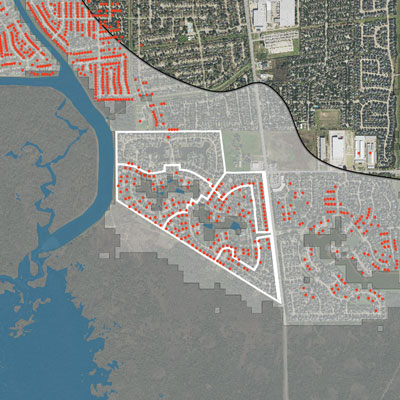
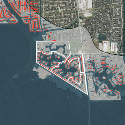
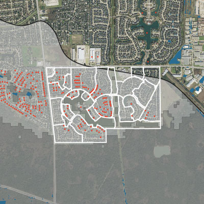
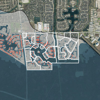
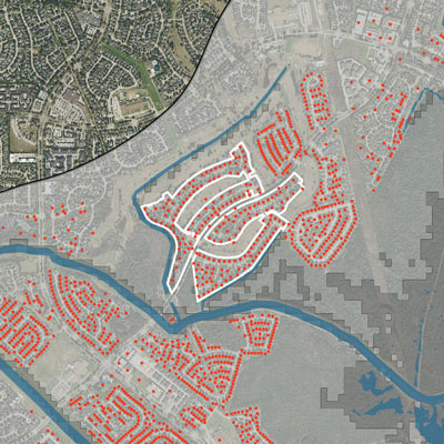
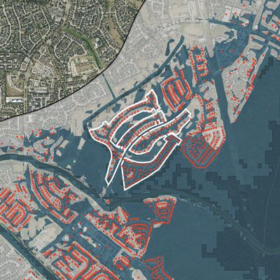
Thousands of homes are wedged between government land and the maximum height of Addicks and Barker Reservoirs.
Army Corps of Engineers data shows subdivisions just beyond the edge of federal government land stayed flooded after Harvey’s rains. The maps at left, based on data from Sept. 16 after flood waters largely receded, show damaged subdivisions just beyond government-owned land. At right, those subdivisions on Sept. 3, days after Harvey’s floodwaters filled reservoirs nearly to capacity.
Structure damaged in Harvey
| Flooding on Sept. 16 | Flooding on Sept. 3 |
|
2000 ft. Edge of reservoir Twin Lakes Subdivision Government-owned land
|
2000 ft. Edge of reservoir Twin Lakes Subdivision Government-owned land
|
|
2000 ft. Edge of reservoir Lakes On Eldridge Subdivision Government-owned land
|
2000 ft. Edge of reservoir Lakes On Eldridge Subdivision Government-owned land
|
|
2000 ft. Edge of reservoir Kelliwood Greens Subdivision Government-owned land
|
2000 ft. Edge of reservoir Kelliwood Greens Subdivision Government-owned land
|
By 2015, the flood control district had issued a warning in a new report that concluded: “Addicks Reservoir does not have the capacity to accept additional runoff anticipated from land development activities.”
That report went to both Harris County and the Texas Water Development Board. Still, development hasn’t stopped, although Harris County recently adopted slightly stronger flood mitigation rules in the area.
The finger-pointing over who allowed that development was going on long before Harvey. And there is certainly plenty of blame to go around.
You could start with the Army Corps, which bought only about 24,500 acres back when it built Addicks and Barker in the 1940s — even though the agency knew at the time that about 8,000 more acres could actually flood in a large enough rainstorm.
“There was only cattle, hay crops and a few rice crops out there at the time,” Long, the Army Corps’ reservoir overseer, said in 2016.
So if private property flooded, it wouldn’t be a big deal.
But Houston kept growing, from less than 400,000 people in 1940 to more than 2 million today. And the areas that had been intended for flood control — the reservoir basins and the fringes of Buffalo Bayou downstream — became desirable land for developers.
In an interview last year, Long said the Army Corps has little to no control over development and that its hands have been tied by local politicians and other factors — including the whims of various presidents and congresses with differing views on how much land the government should own and who controls the Army Corps budget.
If the agency could go back and start over, knowing what it knows now, “our battle lines would definitely be different,” he said.
Hebert, the Fort Bend County judge, said he can’t believe the Corps didn’t buy more land back when it built the projects. In the ‘40s, he said the county bought land for the reservoirs for just $12 an acre, or $170 per acre in today’s dollars.
“We can’t cry over spilled milk right now,” Hebert said. “But a lot of folks have tears, and a lot of milk has been spilled.”
Others say the Army Corps doesn’t deserve the brunt of the blame. After all, local officials are the ones who allowed development on all that non-government-owned land.
Those local officials are now engaged in an intense round of deflection and blame games.
“It’s too easy to look back and say ‘shoulda, woulda, coulda,’” said Emmett, the Harris County judge. “We need to find out what everybody’s role was and then make sure this kind of thing doesn’t happen going forward.”
Emmett said because the reservoirs are inside the city of Houston’s jurisdiction, the city — not Harris County — is responsible for approving “plats” that clear the way for constructing new neighborhoods.
“That’s an outrageous statement,” said Costello, the city’s “flood czar,” who said that Harris County has to approve the plats for new construction, too.
Should the city have rejected the initial plats and stopped the development before it started?
“I don’t have a response to that question, and I won’t respond to that question,” Costello said.
An engineer who used to the work for the Army Corps’ Galveston District and often discloses that he “made a good living working with developers,” Costello said he wasn’t aware the reservoir “flood pools” were that large until a few weeks ago, when he first saw a copy of an Army Corps operating manual.
All the deflection makes it clear to Bedient, the Rice University engineering professor, that local government policies need to change.
“It should be treated as a regional flood problem. The city doesn’t talk to the county. The county certainly doesn’t know how to deal with the Corps of Engineers … Nobody’s in charge,” he said.
“Nobody looks at a plat”
Harris County officials may not have realized the true risks of development around and inside the reservoirs until Tropical Storm Allison. But there is evidence that officials in neighboring Fort Bend County were worried a lot earlier.
Back in the 1990s, when development in Barker Reservoir was really ramping up, Larry Dunbar remembers getting a call from Fort Bend County officials.
Dunbar, an engineer and lawyer who has long consulted on water issues, said officials told him they felt uncomfortable allowing so much development in the reservoirs’ flood pool. So he gave them a few options, he said.
“One option was, don’t allow any development there. And it was like, well, politically we probably can’t do that,” Dunbar remembered. “So I said, another option is, make all the developers elevate the homes above the design pool” — the land behind the dams the Army Corps knew it might have to flood. Dunbar said county officials told him “that may not be practical.”
In the end, over significant opposition from developers, the county agreed to put a one-sentence disclosure of possible “controlled inundation” for plots of land in neighborhoods inside Barker. But the sentence was buried in the plat documents, which are not typically shown to homebuyers.
“It’s not like waving a big red flag,” Dunbar conceded, but it was better than nothing.
Dunbar and a colleague recently filed a class action lawsuit against the Army Corps on behalf of a resident who lives inside Barker’s flood pool.
Hebert, the county judge, said he’s not even sure those small notices on the plats are legal. Anything that could cause property values to drop — and a disclosure that a house is inside a reservoir would fit that category — is a possible governmental “taking” of private property without compensating landowners.
“In my opinion, that was the right thing to do,” Hebert said. But “I think we’re subject to being sued by the property owners.”
By all accounts, neither Harris County nor the city of Houston has required such a disclosure, but Radack, the Harris County commissioner, said he thinks “there should be every kind of disclosure known to man.”
Asked why the county hasn’t done so during his three decades in office, Radack scoffed and pointed to what he considers a more meaningful move by the county: It requires anyone building there to elevate homes six inches higher than Fort Bend County’s regulations.
“Nobody looks at a plat,” he said. “Nobody knows where to go to even see a plat.”
Selling the reservoirs as amenities
Officials didn’t simply sit back and let development occur inside the reservoirs. They actually encouraged it through other key actions — including the construction of a third highway loop around the city that would skirt the western edges of both of the emergency lakes.
Talk about building the Grand Parkway began decades ago, back in the 1980s. Some described the Parkway as visionary because it anticipated Houston’s rapid growth. When completed in 2021, the new loop will be large enough to fit the state of Rhode Island inside of it.
But proponents of sustainable development — including the environmental group Sierra Club, which sued to try to stop its construction — said the Parkway would encourage more suburban sprawl and wetland loss and would worsen flooding problems.
Several years after Allison flooded large swaths of Houston, it was time to build a crucial western segment of the giant loop, known as Segment E. During the litigation, the Sierra Club obtained documents that showed the Army Corps and state agencies also were worried about paving over more wetlands that could absorb floodwaters in the Addicks and Barker watersheds.
Development encroaching on the north side of Addicks Reservoir in Houston on Sept 7, 2016. (Michael Stravato/The Texas Tribune)
The documents included emails from Long, the Corps’ reservoir overseer, who wrote that constructing a new segment of the parkway “further compounds issues and problems that already exist with Addicks and Barker.” Even with flood mitigation, he said, “negative impacts will occur to the reservoirs.”
But Long was overruled by another Corps official, who concluded, “No impacts to the Addicks and Barker Reservoirs are expected.” That conclusion wound up in the Army Corps’ final permit allowing Segment E to be built.
The court documents show that the Texas Commission on Environmental Quality, the state’s environmental regulatory agency, also expressed concerns about that segment of the highway, writing that “permeable surface [prairie and wetlands] loss will contribute to flooding problems” and that “flooding impacts need to be addressed.” Other state and federal agencies, including the U.S. Environmental Protection Agency, raised similar concerns.
The Army Corps received more than 70 requests to hold a public hearing about the project but decided not to. “It is unlikely that new information would be gained by holding a public hearing. Therefore a public hearing will not be held,” the agency wrote in documents made public in the lawsuit.
Houston lawyer Jim Blackburn, who filed the suit on behalf of the Sierra Club, said the documents made clear that the Army Corps “prioritized building the Grand Parkway over fixing the issue with Addicks and Barker development.”
“This is not dumb, bad planning,” he said. “This is very well-thought-out, bad planning.”
Segment E spurred more growth in what’s called the Energy Corridor, a narrow sliver of land along Interstate 10 located smack in the middle of the Addicks and Barker reservoirs.
For people moving into the area, the reservoirs aren’t billed as a disadvantage or threat. Quite the opposite.
In 2001, the Texas Legislature created The Energy Corridor Management District to oversee and promote growth in the area. It touted the reservoirs as “two of the largest unspoiled natural areas of any metropolitan region in the U.S.” — and the parks and sports fields within them as amenities that support an “active, healthy lifestyle.”
Nowhere on its website does the district mention flood risks.
A spokesman for the district declined an interview request, saying it is “more concerned now with getting life and business back to normal and then pursuing our master plan vision for the District that is guiding our efforts to make a more livable, walkable/bikeable and connected place.”
“The District also does not deal with development regulations, which is the City of Houston’s purview,” he added.
No end to development
Local officials say it’s too late to go back and tear up all of the development in the reservoirs. But they’re divided on what should be done now that Harvey has exposed the flood dangers.
Hebert said he’s not sure what can be done to restrict further development in Barker. Because Fort Bend County doesn’t have zoning power, it could try to buy out homes in the reservoir, but that would cost hundreds of millions of dollars; the average value of the 3,000 homes that flooded is $360,000, Hebert said.
And he’s not sure drastic measures are needed. “There were woolly mammoths roaming around the last time that we had rain like this,” he said.
Meanwhile, Harris County has taken some steps. Last year, officials strengthened flood control regulations for developments inside and near Addicks and Barker reservoirs that are within county boundaries.
For the first time ever, some new developments will have to put in detention ponds, which temporarily hold water and then slowly discharge it into nearby streams. They’ll also have to install some form of “retention” that can store the water more permanently. That way, excess water won’t end up in the reservoirs during big storms.
Emmett has also called for more changes to development regulation, though it’s unclear what that would involve. “We need to start over,” he said, “and look at everything.”
Bedient, the Rice University engineering professor, said those regulations will help, but they’re too little, too late. He said the only thing that can really help solve the problem is to build a long-discussed third reservoir upstream of Addicks and Barker to hold excess floodwater.
County and city officials have called loudly for such a project, which would cost at least $300 million, to be funded as part of a federal Harvey recovery package. U.S. Rep. Michael McCaul, a Republican whose district includes part of the greater Houston region, also is championing the project.
But it’s still not clear exactly where a new reservoir would be located. When Potok was assistant director of the Harris County Flood Control District, he tried to get landowners to the table, but “when push came to shove, quite frankly, everybody had to give up something,” he recalled. The effort stalled and hasn’t been revived.
Emmett said he thinks it’s a good idea, but he’s not sure there’s enough undeveloped land left for a new reservoir. “What’s in [that land] now?’” he said. “You could have whole subdivisions already built.’”
Meanwhile, there’s no indication that development in the area will slow — even after Harvey.
Houston Realtor-broker Sam Chaudhry, who also serves on the government affairs committee of the Texas Association of Realtors, said he’s decided not to sell homes in neighborhoods inside the reservoirs anymore.
And he said he would never have sold homes there in the first place if he had known about the risks — information he said the city and Army Corps knew but “didn’t disclose.”
“I found that out from TV, actually,” he said. “I was like, are you kidding me?”
But he’s probably the exception. For-sale signs proliferate in flood-ravaged neighborhoods inside the reservoirs. Chaudhry said many of them will be snapped up by “an army of investors.”
One five-bedroom home in Lakes on Eldridge, the same subdivision where Jeremy Boutor lives, was listed for $678,000 about two weeks before it flooded during Harvey.
The seller’s agent, Moira Holden, tried to put a positive spin on things when she updated the online listing that decreased the asking price by $10,000. “Unfortunately this stunning home did flood and is being refurbished to the highest spec!” it says. “Fabulous chance to choose your finishes!”
When asked if she would disclose to potential buyers that the home was inside Addicks Reservoir, Holden didn’t have a clear answer. “I will obviously disclose whatever we are required to disclose,” she said, pointing out that the home wasn’t in a floodplain. “I would hope that the buyer’s Realtor would do their due diligence on that.”
Edna Meyer-Nelson, a developer who calls herself a “sixth-generation Houstonian,” said she didn’t know that the shopping center she recently bought was in Addicks Reservoir. She said the development didn’t flood during Harvey but that she’d be willing to submit to stricter building regulations as long as everyone else buys in, too.
“We’re filling up everything with cement, and then we expect [the water] to go somewhere,” she said. “There’s nowhere for the water to go. We need to build more retention ponds.”
But she resisted the idea that development inside the reservoirs needs to stop or slow down.
“We’re going to cover every inch of the land that we can cover,” she said. “I think we need to get more ingenious, but I don’t think we need to stop.”
ProPublica and the Texas Tribune are looking into home buyouts after Hurricane Harvey. Has your home flooded repeatedly, and have you volunteered for a buyout? E-mail harvey@propublica.org.
Map sources: US Army Corps of Engineers, Texas Water Development Board, FEMA, Harris County Appraisal District, Fort Bend Central Appraisal District, USGS Orthoimagery. Note: Our graphics do not capture peak flooding between August 26 and Sept. 2 because the Army Corps only posted inundation data beginning on Sept. 3.


