

The persistent march of a warming climate is seen across a multitude of continuous, incremental changes. CO2 levels in the atmosphere. Ocean heat content. Global sea level rise. Each creeps up year after year, fuelled by human-caused greenhouse gas emissions.
And while climate records are being routinely broken, the cumulative impact of these changes could also cause fundamental parts of the Earth system to change dramatically and irreversibly.
These “tipping points” are thresholds where a tiny change could push a system into a completely new state.
Imagine a child pushing themselves from the top of a playground slide. There is a point beyond which it is too late for the child to stop themselves sliding down. Pass this threshold and the child continues inevitably towards a different state – at the bottom of the slide rather than the top.
In this article, Carbon Brief explores nine key tipping points across the Earth system, from collapsing ice sheets and thawing permafrost, to shifting monsoons and forest dieback.
And, over the coming week, Carbon Brief will be publishing guest articles from experts in four of the tipping points covered here.
Tipping towers
A glance at the news media on any given week will likely highlight all sorts of climate change impacts. From declining Arctic sea ice and record-breaking heatwaves to melting glaciers and worsening droughts, the increase in global average temperature is being felt around the world.
Broadly, these impacts reflect gradual changes caused by a climate that is steadily warming. Scientists have estimated, for example, that for every tonne of CO2 emitted into the atmosphere, summer sea ice cover in the Arctic shrinks by three square metres.
However, there are parts of the Earth system that have the potential to change abruptly in response to warming. These systems have “tipping points”, explains Prof Tim Lenton, director of the Global Systems Institute at the University of Exeter. He tells Carbon Brief:
“A climate tipping point, or any tipping point in any complex system, is where a small change makes a big difference and changes the state or the fate of a system.”
So, rather than a bit more warming causing slightly hotter heatwaves or more melting of glaciers, it causes a dramatic shift to an entire system.
That extra bit of warming would be, as the saying goes, the straw that breaks the camel’s back. Or, to use a more animal-friendly metaphor, a game of Jenga – where a particular component within the Earth system, such as an ice sheet, circulation pattern or ecosystem, is represented by the tower of blocks.
Animation by Tom Prater for Carbon Brief.
The gradual increase in global temperature sees block after block removed from the tower and placed on top. As time goes on, the tower becomes more and more misshapen and unstable. At some point, the tower can no longer support itself and it tips over.
In the game of Jenga, the tower collapses in a split second. For a component of the Earth system, the shift to one physical state to another may take many decades or centuries. But the feature they have in common is that once the collapse has started, it is virtually impossible to stop.
It is worth noting that a tipping point can be caused by natural fluctuations in the climate as well as by an external forcing, such as global warming. These are called “noise-induced” tipping points and include, for example, periods of abrupt change during the last ice age called “Dansgaard-Oeschger (D-O) events”.
Natural fluctuations can also be the final nudge for a tipping point pushed to the brink by human-caused climate change, says Prof Mat Collins, joint Met Office chair in climate change at the University of Exeter and coordinating lead author on the “Extremes, Abrupt Changes and Managing Risks” chapter of the Intergovernmental Panel on Climate Change (IPCC) special report on the ocean and cryosphere in a changing climate (“SROCC”). He tells Carbon Brief:
“As you approach the edge of the cliff, a small random gust of wind is more likely to blow you over the edge. This is more prevalent in biological systems. A strong marine heatwave in one year can wipe out a large coral ecosystem for many decades – or, perhaps, even permanently. The heatwave is a result of natural fluctuations, but becomes more likely and more extreme with an increasing average trend.”
Irreversible change?
The theory of potentially abrupt changes in the Earth system is not new. In a Nature commentary in 1987, for example, Prof Wally Broecker of Columbia University – who died in 2019 – warned that palaeoclimate data suggests the “Earth’s climate does not respond to forcing in a smooth and gradual way. Rather, it responds in sharp jumps which involve large-scale reorganisation of Earth’s system”.
The term “tipping point” itself was popularised by journalist and author Malcolm Gladwell in his book of the same name, published in 2000. Gladwell describes tipping points as “the moment of critical mass, the threshold, the boiling point”, and explores examples throughout human society:
“There was a tipping point for [declining] violent crime in New York in the early 1990s, and a tipping point for the reemergence of Hush Puppies, just as there is a tipping point for the introduction of any new technology.”
In the years since, the term has been used increasingly in scientific circles. However, this has not been without controversy. There are, for example, many different views on how the term should be defined and used, explains Collins:
“There has been an intensive debate in the field of tipping points, abrupt change and irreversibility about the definitions of these terms. They range from the very mathematical to those which are intended to be understood by policymakers.”
According to a 2009 paper on the use of the term “tipping points” in climate science and the media, a presentation (pdf) in 2005 by Dr James Hansen of Columbia University’s Earth Institute helped “initiate a tipping point trend in climate change communication that was quickly reflected in public debate”.
In Hansen’s talk – a tribute to scientist Prof Charles Keeling, given at the American Geophysical Union (AGU) Fall Meeting – Hansen warned that “we are on the precipice of climate system tipping points beyond which there is no redemption”.
By its Fall Meeting of 2008, the AGU had an entire half-day session dedicated to climate tipping points. A Science briefing about the meeting declared that “tipping points, once considered too alarmist for proper scientific circles, have entered the climate change mainstream”.
A year earlier, the IPCC had published its fourth assessment report (“AR4”, pdf). This was the first of its assessment reports to use the term “tipping point” – though the third assessment report (“TAR”, pdf) in 2001 had discussed “large-scale discontinuities” that have the “potential to trigger large-scale changes in Earth systems”. Indeed, speaking to a journalist at the time, chapter lead author Prof Hans Joachim Schellnhuber explained that “these are, more or less, tipping points”.
AR4 adopted a definition of a tipping point based on a 2002 report led by Penn State scientist Prof Richard Alley for the US National Research Council. It states:
“Technically, an abrupt climate change occurs when the climate system is forced to cross some threshold, triggering a transition to a new state at a rate determined by the climate system itself and faster than the cause.”
The IPCC’s definition in its fifth assessment report (“AR5”, pdf), published in 2013-14, gives more detail:
“We define abrupt climate change as a large-scale change in the climate system that takes place over a few decades or less, persists (or is anticipated to persist) for at least a few decades, and causes substantial disruptions in human and natural systems.”
Typically, definitions for a tipping point fall into two categories, says Dr Ricarda Winkelmann, junior professor of climate system analysis at the Potsdam Institute for Climate Impact Research (PIK). She explains to Carbon Brief:
“One is simply that one vital part of the climate system shows some kind of threshold behaviour and that means that a small perturbation around that element can cause a huge qualitative change. And then there’s another definition that actually says there needs to be a positive feedback mechanism associated with the element. So that means there is something that’s self-reinforcing and then that could lead to irreversible changes as well.”
Passing an irreversible tipping point would mean a system would not revert to its original state even if the forcing lessens or reverses, explains Dr Richard Wood, who leads the Climate, Cryosphere and Oceans group in the Met Office Hadley Centre. He tells Carbon Brief:
“In some cases, there is evidence that once the system has jumped to a different state, then if you remove the climate forcing, the climate system doesn’t just jump back to the original state – it stays in its changed state for some considerable time, or possibly even permanently.”
This is known as “hysteresis”. It occurs when a system undergoes a “bifurcation” – which means to divide or fork into two branches – and it is subsequently difficult, if not impossible, for the system to revert to its previous state.
For example, part of the reason that Greenland has an ice sheet today is that it has had that ice sheet for hundreds of thousands of years. If the Greenland ice sheet were to pass a tipping point that led to its disintegration, simply reducing emissions and lowering global temperatures to pre-industrial levels would not bring it back again. It would probably require another ice age to achieve that.
Similarly, returning to the Jenga analogy, the amount of energy required to rebuild the tower once it collapsed is significantly greater than the energy used to tip it over.
The extent to which the tipping points considered in this article are irreversible is just one of the many uncertainties that researchers are still exploring. Nonetheless, each of the nine – explained below – are examples of where seemingly small changes have the collective potential to pack a potent punch.
Shutdown of the Atlantic Meridional Overturning Circulation
The Atlantic Meridional Overturning Circulation (AMOC) is a system of currents in the Atlantic Ocean that brings warm water up to Europe from the tropics and beyond.
The illustration below shows the two main features of the AMOC: the first is the flow of warm, salty water in the upper layers of the ocean northwards from the Gulf of Mexico (red line). This is made up of the “Gulf Stream” to the south and the “North Atlantic Current” further north. The second is the cooling of water in the high latitudes of the Atlantic, which makes the water more dense. This denser water then sinks and returns southwards towards the equator at much deeper depths (blue line).
The Atlantic Meridional Overturning Circulation. Reprinted by permission from Springer. Praetorius (2018) North Atlantic circulation slows down, Nature.
The AMOC forms part of a wider network of global ocean circulation patterns that transports heat all around the world. It is “driven by deep water formation”, explains Prof Stefan Rahmstorf, professor of physics of the oceans at Potsdam University and co-chair of earth system analysis at PIK. This is “the sinking of dense, therefore heavy, water in the high latitudes of the North Atlantic”, he explains to Carbon Brief.
Climate change affects this process by diluting the salty sea water with freshwater and by warming it up, he says:
“The dilution happens through increased rainfall and also melting of continental ice in the vicinity of mainly the Greenland ice sheet. And that makes the water lighter and, therefore, unable to sink – or at least less able to sink – which, basically, slows down that whole engine of the global overturning circulation.”
Recent research suggests that the AMOC has already weakened by around 15% since the middle of the 20th century. This is in line with projections by climate models, says Dr Richard Wood. However, the question remains at what point a weakening tips over into a complete shutdown, he explains:
“Perhaps a much less likely, but larger cause for concern is whether there’s a threshold beyond which the AMOC becomes unsustainable and at that point – if you pass that threshold – then over some period of time, the AMOC might reduce to zero or even potentially a reversed circulation. And that would have big impacts on the climate of, well, the whole northern hemisphere, but particularly Europe.”
This shutdown could happen because the AMOC is a self-reinforcing system, explains Rahmstorf:
“The circulation itself brings salty water into the high-latitude Atlantic and the salty water increases the density. And so we can say the water is able to sink because it is salty and it is salty because there is this circulation. So it’s like a self-reinforcing system.”
Such a system can only be pushed “up to a limit”, says Rahmstorf, after which the self-reinforcing system actually works to further weaken the circulation. Too much freshwater in the North Atlantic slows the circulation, preventing it from pulling salty water up from the south. Thus, the North Atlantic freshens even more and the circulation weakens further – and so on. It “really is an on-off system”, he adds.
There is still a lot of uncertainty about where exactly this tipping point is, says Rahmstorf. To the extent that “nobody really knows”, he adds:
“But, I would say, most people think that to trigger a real shutdown would require substantial global warming – like 3C or 4C [above pre-industrial levels]. And we could pretty well minimise this risk by limiting the warming to below 2C. So, if we actually take the Paris Agreement seriously, then I would feel relatively relaxed about the risk of a shutdown. But if we continue on the current path and heading for three or more degrees, then this becomes a really serious concern.”
(According to Climate Action Tracker, current global climate policies put the world on track for around 3C of warming.)
And it is “important to emphasise that climate models are not suggesting a complete shutdown of the AMOC in the next 100 years or so”, adds Wood: “We’re looking at what we call a ‘low-probability, high-impact’ event”.
The IPCC’s special report on 1.5C of warming, for example, concludes that while “it is very likely that the AMOC will weaken over the 21st century”, there is “no evidence indicating significantly different amplitudes of AMOC weakening for 1.5C versus 2C of global warming, or of a shutdown of the AMOC at these global temperature thresholds”.
Were the AMOC to cross a tipping point, models suggest it would trigger a “quick decline that takes decades and then a kind of slower decline which might take even hundreds of years”, says Wood.
This would be “practically irreversible” on human timescales, notes Rahmstorf:
“Depending on the exact nature of the stability of the circulation, it could be shutdown basically indefinitely for thousands of years into a new stable shutdown state. Or it could eventually recover – both things we observe in different models. But, on a timescale if you’re just interested in what happens in the next 200-300 years or so, that doesn’t actually make a difference because it does stay off then once it dies for quite a long time.”
This “shutdown” state is an example of hysteresis, explains Wood in the video below. It means that once you go over the tipping point, even if global warming is stopped or reversed, the AMOC does not necessarily switch back on again immediately.
As the AMOC plays a crucial role in bringing heat up from the tropics, a shutdown would cause “widespread cooling around the whole of the northern hemisphere, but particularly around western Europe and the east coast of North America”, says Wood. This could be in the order of “several degrees, possibly 5C”, he adds.
This cooling would have knock-on impacts for rainfall patterns as there would be less evaporation from the North Atlantic, says Wood. This could either offset or magnify the changes caused by global warming, he says:
“In northern parts of Europe, we might expect from global warming to see wetter winters and then the drying would compensate. In other regions, more in southern Europe, where we would already be expected to see a drying signal from the global-warming signal, so paradoxically, the cooling would give you a further drying. So it would actually reinforce the climate-change signal.”
The knock-on impacts would be considerable. For example, a recent study in the new journal Nature Food suggests that an AMOC shutdown would cause “widespread cessation of arable farming” in the island of Great Britain with “losses of agricultural output that are an order of magnitude larger than the impacts of climate change without an AMOC collapse”.
In addition, there will be implications for the ocean itself, notes Rahmstorf:
“The whole North Atlantic ecosystem is adapted to the existence of this overturning circulation, which really sets the conditions – the seasonal cycle, the temperature, the nutrient conditions – in the North Atlantic, and so the intricate web of the Atlantic ecosystem will be substantially disrupted if allow such a massive change in the ocean circulation to happen.”
Finally, research suggests that the collapse of the AMOC could itself trigger other tipping points. As the SROCC explains:
“For example, a collapse of the AMOC may induce causal interactions like changes in ENSO [El Niño–Southern Oscillation] characteristics, dieback of the Amazon rainforest and shrinking of the West Antarctic Ice Sheet due to seesaw effect, ITCZ [Intertropical Convergence Zone] southern migration and large warming of the Southern Ocean.”
However, the SROCC notes that “such a worst-case scenario remains very poorly constrained” as a result of the large uncertainties around how systems such as AMOC will respond to warming.
West Antarctic ice sheet disintegration
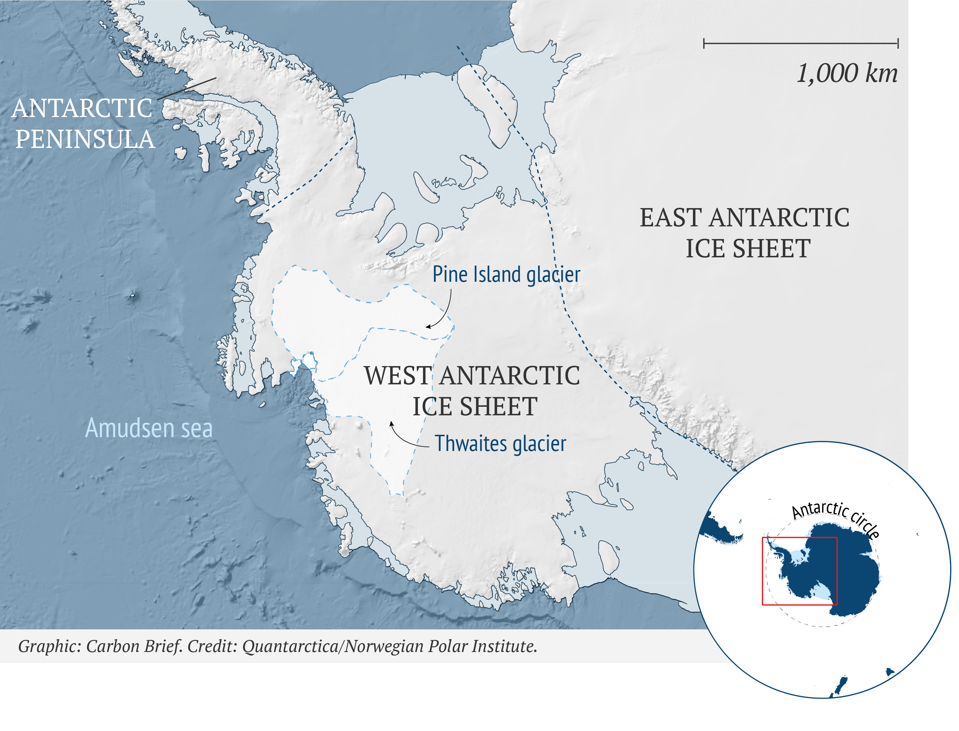
The West Antarctic Ice Sheet (WAIS) is one of three regions making up Antarctica. The other two are East Antarctica and the Antarctic Peninsula, with the Transantarctic Mountain range dividing east from west.
Although much smaller than its neighbour to the east, the WAIS still holds enough ice to raise global sea levels by around 3.3 metres. Therefore, even a partial loss of its ice would be enough to change coastlines around the world dramatically.

The long-term stability of the WAIS is of particular concern because it is a “marine-based” ice sheet. As the IPCC’s special report on the ocean and cryosphere in a changing climate (“SROCC”) explains, this means that it sits “upon bedrock that largely lies below sea level and [is] in contact with ocean heat, making [it] vulnerable to rapid and irreversible ice loss”.
The map below shows the elevation of Antarctic bedrock; the greens, yellows and reds indicate areas above sea level, while the whites and blues show areas below it – by as much as 2.5km. The WAIS itself is more than 4km thick in places.

Bedrock topography below the existing ice sheets in Antarctica. Shading indicates areas above (green, yellow and red) and below (white and blue) sea level. Source: IPCC SROCC (2019) Figure 4.7 (pdf)
Acting under the force of gravity, the ice of the WAIS gradually flows out from its interior towards the coast and into the Southern Ocean. Fresh snowfall on the interior of the ice sheet replenishes the lost ice. If the ice sheet loses more ice to the ocean than it gains in snow, it adds to global sea levels.
For example, analysis published in Nature in 2018 showed that the rate of ice loss from the WAIS had tripled from 53bn tonnes a year during 1992-97 to 159bn tonnes a year in 2012-2017.
Where the ice meets the ocean, floating ice shelves form. These ice shelves have a “buttressing” effect, holding back the glaciers on land that flow into them.
Sitting on the ocean surface, ice shelves are at risk of melting from above and below from warm air and water, respectively. In the Antarctic Peninsula, for example, research has shown that the collapse of the Larsen B ice shelf in 2002 was primarily driven by warm air temperatures. While the Larsen C ice shelf, which is “thinning rapidly”, is being melted from above and below.
Because ice shelves float on water, their collapse does not directly cause sea level rise. But thinning and/or collapse of the WAIS’s ice shelves could trigger a positive feedback loop that sees rapid and irreversible loss of land ice into the ocean – which would add to sea levels. This theory is called “marine ice sheet instability” (MISI).
The illustration below shows how it works. As an ice shelf thins, more ice lifts off the seafloor and begins to float. This pushes back (see blue arrows) the “grounding line” – the transition point between grounded and floating ice (indicated by dashed lines). Floating ice flows more rapidly than grounded ice and so the rate of ice flow near the grounding line increases (black arrows). Faster flow means thinning, which may in turn cause more ice to lift off and float. And because greater thickness also causes the ice to flow faster, grounding-line retreat into deeper sections of the ice sheet can also produce faster flow.
What makes this a positive feedback loop is the retrograde slope of the WAIS’s bedrock. Not only is much of the bedrock beneath the ice sheet below sea level, large portions of it slope downwards away from the coast. This means that once ice sheet retreat reaches this point, it is self-sustaining.

Illustration of Marine Ice Sheet Instability, or MISI. Thinning of the buttressing ice shelf leads to acceleration of the ice sheet flow and thinning of the marine-terminated ice margin. Because bedrock under the ice sheet is sloping towards the ice sheet interior, thinning of the ice causes retreat of the grounding line followed by an increase of the seaward ice flux, further thinning of the ice margin, and further retreat of the grounding line. Credit: IPCC SROCC (2019) Fig CB8.1a
(There is also an additional feedback loop mechanism that could further endanger the WAIS. This is called Marine Ice Cliff Instability (MICI), which would see towering cliffs of glacier ice collapse into the ocean under their own weight. The theory is still under debate.)
In terms of tipping-point behaviour, most research has focused on the Amundsen Sea sector of the WAIS into which six glaciers drain. As far back at the 1980s, this region was identified as the “weak underbelly” of the WAIS. Here, the grounded ice flows directly into the ocean with “no significant ice shelf barrier” to hold it back.
Antarctica’s contribution to global sea levels is currently dominated by ice loss from Amundsen sea sector glaciers. Sections of the Thwaites and Pine Island glaciers, for example, are thinning at rates of 49 and 45cm per year, respectively, on average over 1992-2017.

1,000 km
Antarctic
peninsula
Ronne ice shelf
East Antarctic
Ice Sheet
Pine Island glacier
South pole
West Antarctic
Ice Sheet
Transantarctic mountains
Amudsen sea
Thwaites glacier
Ross ice shelf
Graphic: Carbon Brief. Credit: Quantarctica/Norwegian Polar Institute.
Research indicates that glaciers in this sector are “undergoing a marine ice sheet instability that will significantly contribute to sea level rise in decades to centuries to come”.
For example, model simulations in a 2014 study in Science have suggested that the “process of marine ice-sheet destabilisation is already under way on Thwaites Glacier”. The study notes:
“Although [ice] losses are likely to be relatively modest over the next century (<0.25 mm/year of sea level equivalent, SLE), rapid collapse (>1 mm/year of SLE) will ensue once the grounding line reaches the basin’s deeper regions, which could occur within centuries.”
This rapid collapse “would probably spill over to adjacent catchments, undermining much of West Antarctica”, the study adds.
The SROCC is also a little more circumspect in its conclusions. It says that rapid mass loss due to glacier flow acceleration in this region “may indicate the beginning of MISI”. However, it also notes that “observational data are not yet sufficient to determine whether these changes mark the beginning of irreversible retreat”.
Prof Tim Lenton tells Carbon Brief that whether all or part of the WAIS has already passed a tipping point for irreversible loss is “the big concern at the moment” because of the sea level rise it would cause.
Overall, the SROCC assessment of “partial West-Antarctic Ice sheet collapse” is that it is potentially abrupt and would be “irreversible for decades to millennia”. It ascribes “low confidence” to a collapse during the 21st century.
A Nature Climate Change review paper published in 2018 concluded that “under sustained warming, a key threshold for survival of Antarctic ice shelves, and thus the stability of the ice sheet, seems to lie between 1.5 and 2C mean annual air temperature above present”.
This temperature threshold refers to regional warming in Antarctica, rather than a global average figure. However – as lead author Prof Frank Pattyn explains to Carbon Brief – because the poles warm more quickly than the global average, 2C of warming on Antarctica from present is approximately equivalent to 2C of global warming since pre-industrial levels.
Pattyn, a glaciologist and co-director of the Laboratoire de Glaciologie at the Université libre de Bruxelles, also notes that a tipping point for the WAIS “is not sharply defined”. Referring to the different “Representative Concentration Pathway” emissions scenarios, he adds:
“Studies show that under RCP2.6 the ice sheets continue to lose mass but seem stable, while for RCP4.5, in some cases irreversible mass loss is encountered. However, only a few studies consider the full range of RCPs and most of them only compare RCP2.6 to RCP8.5.”
RCP2.6: The RCPs (Representative Concentration Pathways) are scenarios of future concentrations of greenhouse gases and other forcings. RCP2.6 (also sometimes referred to as “RCP3-PD”) is a “peak and decline” scenario where stringent mitigation and carbon dioxide removal technologies mean atmospheric CO2 concentration peaks and then falls during this century. By 2100, CO2 levels increase to around 420ppm – around 20ppm above current levels – equivalent to 475ppm once other forcings are included (in CO2e). By 2100, global temperatures are likely to rise by 1.3-1.9C above pre-industrial levels.
RCP4.5: The RCPs (Representative Concentration Pathways) are scenarios of future concentrations of greenhouse gases and other forcings. RCP4.5 is a “stabilisation scenario” where policies are put in place so atmospheric CO2 concentration levels off around the middle of the century, though temperatures do not stabilise before 2100. These policies include a shift to low-carbon energy technologies and the deployment of carbon capture and storage. In RCP4.5, atmospheric CO2 sits at 540ppm by 2100 – roughly 140ppm higher than now – equivalent to 630ppm once other forcings are included (in CO2e). By 2100, global temperatures are likely to rise by 2-3C above pre-industrial levels.
RCP8.5: The RCPs (Representative Concentration Pathways) are scenarios of future concentrations of greenhouse gases and other forcings. RCP8.5 is an “very high baseline” emission scenario brought about by rapid population growth, high energy demand, fossil fuel dominance and an absence of climate change policies. This scenario is the highest of the RCPs and sees atmospheric CO2 rise to around 935ppm by 2100, equivalent to 1,370ppm once other forcings are included (in CO2e). The likely range of global temperatures by 2100 for RCP8.5 is 4.0-6.1C above pre-industrial levels. The release of the Shared Socioeconomic Pathways (SSPs) has introduced a number of additional “no-new-policy” scenarios, meaning RCP8.5 is no longer the sole option available to researchers as a high-end no-mitigation pathway.
Evidence from Earth’s distant past also suggests the WAIS has collapsed before. For example, a Nature Geoscience review paper from 2011 notes:
“The palaeo record strongly suggests that the WAIS largely disappeared, perhaps during the past few hundred thousand years and more confidently during the past few million years, in response to warming similar to or less than that projected under business-as-usual CO2 emission scenarios for the next few centuries.”
Amazon rainforest dieback
The Amazon rainforest is the largest rainforest in the world. Spanning nine countries in South America, it is twice the size of India. The lush vegetation is a haven for millions of species of plants, insects, birds and animals.
As its name suggests, a rainforest is sustained by very wet conditions. But the forest itself plays a critical role in the local climate. As the forest is saturated with heavy rains, much of this moisture is returned to the atmosphere through evaporation. In addition, transpiration of moisture from plant leaves transfers water from the soil into the atmosphere. These two processes combined are called “evapotranspiration”.
These processes keep the atmosphere moist, but also help drive convection – strong upward motion of the air – which, ultimately, creates clouds and more rainfall. Research published in the 1970s showed that the Amazon generates around half of its own rainfall.
The result is that either reducing the amount of rainfall or the amount of forest can shift the climate into a drier state that cannot support a rainforest. There are three potential causes of this, explains Prof Richard Betts, head of climate impacts at the Met Office Hadley Centre and chair of climate impacts at the University of Exeter.
The first is a decline in rainfall in response to a warming climate. Model projections suggest this would be a result of “particular patterns of sea surface temperature (SST) change in the tropical Atlantic and Pacific”, says Betts, but there is a lot of variation between models as to how strong the impact would be on the Amazon. The second is a response to reduced transpiration in response to higher CO2, Betts says:
“Microscopic pores in plant leaves open less widely under higher CO2. So the plants lose less water and less transpiration means less water going back into the atmosphere.”
Finally, the third cause would be the direct impact of deforestation – fewer trees mean less evapotranspiration and less moisture entering the atmosphere.

Aerial view of deforestation in the Amazon rainforest, near Belém, Brazil. Credit: Sue Cunningham Photographic / Alamy Stock Photo.
There is only so much drying the Amazon could tolerate before the rainforest would no longer be able to support itself. Beyond this point, the forest would see widespread “dieback” and transition to savannah – a drier ecosystem dominated by open grasslands with few trees.
In the clip below, Betts summarises how the Amazon could be pushed “beyond the point of no return”.
Dr David Lapola – a research scientist at the University of Campinas in Brazil – cautions that, while it is “reasonable to think that deforestation and fire could of course contribute to reach that [Amazon dieback] tipping point”, the hypothesis is predominantly based on model simulations. He tells Carbon Brief:
“It happens that the same model simulations show that if the so-called ‘CO2 fertilisation effect’ – as a basic input to photosynthesis, when atmospheric CO2 increases it theoretically enhances plant productivity – really exists and expresses itself in the Amazon, then it would counteract the bad effects of higher temperature and lower rainfall, leaving the forest basically the way it is now. The problem is that we don’t have experimental evidence proving the existence, magnitude and duration of such CO2 fertilisation effect in the tropics.”
If there is indeed a threshold, where might it lie? Betts says that “3C is the lowest level of warming that might trigger it, but it might need much higher warming”.
A Science Advances editorial last year by Prof Carlos Nobre of the University of Saõ Paulo’s Institute for Advanced Studies and Prof Thomas Lovejoy of George Mason University noted that “many studies show that in the absence of other contributing factors, 4C of global warming would be the tipping point to degraded savannahs in most of the central, southern and eastern Amazon”.
One of those contributing factors is deforestation, which could hasten a shift to savannah as a “fragmented forest is probably more sensitive to rainfall reductions driven by global heating”, says Betts.
In a recent interview with Yale Environment 360, Nobre explains that he “published a paper about this in Science in 1990 that said if we deforest parts of the Amazon, it will become a savannah”. He adds:
“The post-deforestation climate will no longer be a very wet climate like the Amazon. It will become drier, it will have a much longer dry season, like the long dry seasons in the savannahs in the tropics in Africa, South America and Asia.”
Without global warming, a tipping point for Amazon dieback could be reah “if you exceed 40% total deforested area in the Amazon”, says Nobre:
“About 60 to 70% of the Amazon forest would turn into a dry savannah, especially in the southern and northern Amazon, areas that now border savannahs. Only the western Amazon near the Andes, which is very rainy, the forest will still be there.”
Nobre estimates that approximately 17% of the Amazon rainforest has been cleared so far – principally for cattle ranching and soy plantations. While rates of deforestation slowed in the early 21st century, they have recently rebounded. In the Brazilian Amazon, for example, tree clearance fell by two-thirds between 2005 and 2011, but 2018 saw annual rates rise to their highest levels in a decade. In 2019, deforestation rose again – with rates 85% higher than in 2018.
Reports suggest that a change in policy under Brazilian president Jair Bolsonaro is encouraging development at the expense of the rainforest.
Factoring in climate change and “widespread use of fire” brings the tipping point closer, say Lovejoy and Nobre in their editorial. They estimate that a “tipping point for the Amazon system to flip to non-forest ecosystems in eastern, southern and central Amazonia [lies] at 20-25% deforestation”. Nobre recently told the Guardian that this could happen “in 15 to 20 years”.
There is “no point in discovering the precise tipping point by tipping it”, their editorial says, but instead to “build back a margin of safety…by reducing the deforested area to less than 20%”.
The impacts of losing the Amazon rainforest would be felt locally and globally. As well as being an ecological “catastrophe” for wildlife, the socioeconomic damage to the region could amount to $0.9-3.6tn over a 30-year period.
“The reduced evaporation and reduced convection would alter atmospheric circulation worldwide,” says Betts, which would influence weather patterns around the world.
Amazon dieback would also make it more difficult to tackle climate change, he notes:
“Increased release of CO2 from forest fires and tree death would accelerate CO2 rise, and with the forest gone we would also have lost an important carbon sink which would mean that deeper emissions cuts would be needed to stop the rise in atmospheric CO2.”
There are already “ominous signals” of changes in the Amazon, say Lovejoy and Nobre in another Science Advances editorial published in December 2019:
“Dry seasons in Amazonian regions are already hotter and longer. Mortality rates of wet climate species are increased, whereas dry climate species are showing resilience. The increasing frequency of unprecedented droughts in 2005, 2010 and 2015/16 is signaling that the tipping point is at hand.”
Lapola agrees that “we may be already observing” a shift in the Amazon system. He explains:
“First evidence: a study has shown that the dry season is already getting longer – by a few days in the last decade – in south Amazonia (Mato Grosso and Rondonia). Second evidence: a recent study showed that forest composition is already changing towards tree species that are more resistant to drought. This suggests that the dieback may be more subtle than previously thought, but not less catastrophic.”
The IPCC’s fifth assessment report (“AR5”, pdf) describes dieback of tropical forests as “potentially abrupt”, but “reversible within centuries”. Whereas in a recent Nature “world view” piece, Nobre writes that a recovery from an Amazon tipping point would be “probably impossible”.
Whether a reversal would be achievable, at the very least it would be slow, adds Betts:
“Reforestation or natural regrowth in places with less severe drying could help increase rainfall levels again. Loss of forests on passing the tipping would be quicker though – forest loss can be quite rapid through fire and tree death, but return is slower because it is limited by how fast new trees grow.”
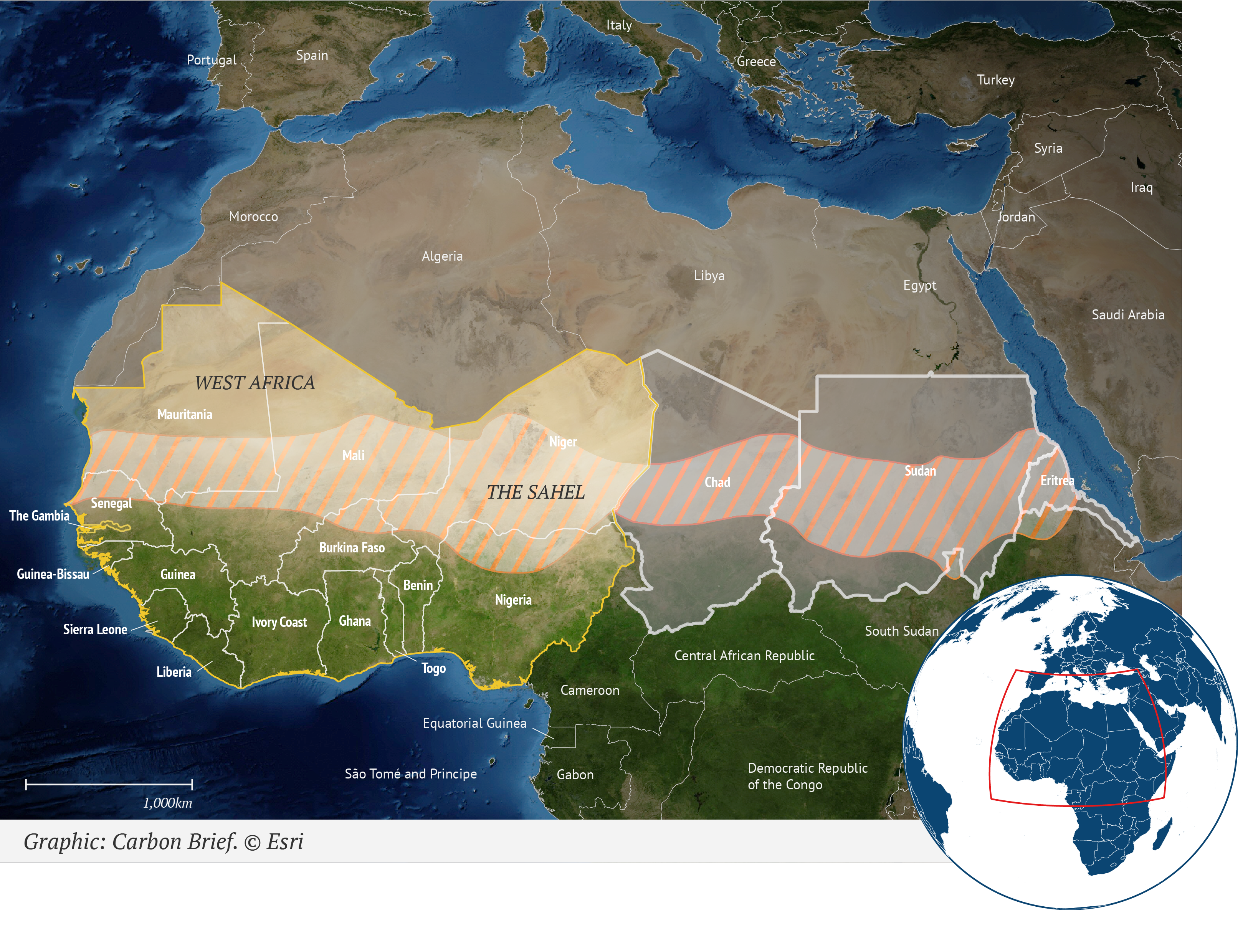
West African monsoon shift
The term “monsoon” in its strictest sense refers to the seasonal reversal of winds and its accompanying rainfall. Along with India, West Africa is one of the few places on Earth where this happens.
The West African monsoon (WAM) brings rainfall to West Africa and the Sahel – a band of semi-arid grassland sandwiched between the Sahara desert to the north and tropical rainforests to the south. The Sahel stretches from the Atlantic coast of Mauritania and Senegal through to Sudan, Eritrea and the Red Sea.

Italy
Spain
Portugal
Greece
Turkey
Syria
Iraq
Morocco
Jordan
Algeria
Libya
Egypt
Saudi Arabia
WEST AFRICA
Mauritania
Niger
Mali
Sudan
Eritrea
Chad
THE SAHEL
Senegal
The Gambia
Burkina Faso
Guinea-Bissau
Guinea
Benin
Nigeria
Ghana
Ivory Coast
Sierra Leone
South Sudan
Central African Republic
Togo
Liberia
Cameroon
Equatorial Guinea
Democratic Republic
of the Congo
São Tomé and Principe
Gabon
1,000km
Graphic: Carbon Brief. © Esri
The WAM is a feature of the northern hemisphere summer. West Africa’s dry season, which runs from November through to May, sees prevailing winds “come from the desert, so they’re dry, dusty winds”, says Dr Alessandra Giannini, a senior research scientist at Columbia University (currently at the Laboratoire de Météorologie Dynamique in Paris as part of a “Make Our Planet Great Again” grant). The shift to the wet season sees this system switch, she explains to Carbon Brief:
“When the system reverses, the low pressure over the Sahara – or the land [more generally] – drives winds from the southwest inland and those are moist winds because they’re from the ocean.”
The moisture that the winds bring to the region is part of the Intertropical Convergence Zone (ITCZ), a huge belt of low pressure that encircles the Earth near the equator. Ultimately, the monsoon is being driven by insolation, says Giannini, as the ITCZ wanders north and south across the tropics each year, roughly tracking the position of the sun through the seasons.
(Giannini emphasises that, while the ITCZ and monsoon are “part of the same season and the same latitudinal migration of the rain band”, some researchers prefer to “distinguish between the ITCZ over the ocean from the monsoon inland” and so do not use the terms interchangeably.)
The Sahel marks the ITCZ’s most northerly position and the monsoon brings rain to the region from around June to September.
But the West African monsoon is notoriously unreliable. Between the late 1960s and 1980s, a lack of rain hit much of the Sahel, with average rainfall declining by more than 30% over most of the region compared to the 1950s. This plunged the region into an extended drought, contributing to a famine that killed tens of thousands of people and triggering an international aid effort.

Sahel precipitation index for June to October over 1901-2017 (where Sahel = 20-10 degrees N and 20 degrees W to 10 degrees E). Shown as precipitation anomalies from a 1901-2017 baseline. Credit: Joint Institute for the Study of the Atmosphere and Ocean at the University of Washington.
It was Giannini’s 2003 Science paper that identified that the cause of the drought primarily lay in warm SSTs around Africa, not desertification caused by farmers and an expanding population. (Earlier work had shown the connection between SSTs and Sahel rainfall variability more generally.)
The warm ocean temperatures reduced the temperature contrast between the continent in the hot summer and the cooler surrounding waters. This saw the monsoon rains shift southwards away from the Sahel, causing drought. The effect was reinforced by the “climate-vegetation feedback”, where drier conditions saw less vegetation growth, a reduction in evapotranspiration and even less rainfall.
Subsequent research by Giannini has shown the combination of warming of the tropical oceans (in response to rising greenhouse gases) and cooling in the North Atlantic (as a result of air pollution from northern hemisphere countries) led to drying of the Sahel.
Rainfall in the Sahel has since shown a partial recovery. This is due, in part, to a warming climate and a reduction in air pollution rates. These changes show that the WAM is a “very sensitive system”, says Giannini and the Sahel is most at risk because it is at the edge of the monsoon.
The past also hints that a tipping point “is in the [WAM] system”, says Giannini:
“So the past shift – the abruptness of the onset of drought in the late 60s-early 70s – is an indication that the system is sensitive and so it could happen again.”
Theory suggests that a warming climate could actually bring more rainfall to the Sahel. As land heats up faster than the water, rising global temperatures could strengthen the land-sea contrast that helps drive the WAM northwards each year. This could bring more rain to the Sahel and, perhaps, see vegetation return to some southern parts of the Sahara.

Drought in the Sahel region of Mali, between 1984-85. Credit: frans lemmens / Alamy Stock Photo.
There is evidence of similar changes in Earth’s distant past. During the African Humid Period (AHP) around 11,000 to 5,000 years ago, natural oscillations in the Earth’s orbit around the sun – assisted by various feedback mechanisms – saw the WAM strengthen, bringing greater rainfall into North Africa. Evidence from palaeoclimate data – such as lake sediments – suggest the region was widely covered with vegetation and deep freshwater lakes during this time, resulting in a “Green Sahara”.
Research has suggested that the “onset and termination of this humid period were very abrupt, occurring within decades to centuries”, although this is still debated.
But the AHP is some distance from being an analogue for the modern day. The changes were being driven primarily by the sun, not large increases in greenhouse gases. Therefore, it provides limited insight into how the WAM will be affected by climate change.
Prof Martin Claussen, professor of meteorology at the University of Hamburg and director at the Max Planck Institute for Meteorology tells Carbon Brief that even in model projections under “strong warming”, the “response of the Sahara is much weaker than it was in response to the change in insolation several thousand years ago”. So, rather than a Green Sahara, projections suggest a “shift of the Sahel zone to the north”, he says.
The response to recent warming has actually been more variability in the WAM, Giannini says:
“In some ways, we are seeing the wetting already, but it’s a wetting that is different also from the past in that it seems to be made up of more extreme events – so more extreme rains and maybe longer periods of dry spells interspersed.”
And, more generally, projections from different climate models have suggested both drier and wetter futures for the Sahel under a changing climate – with the latter linked to a tipping point of 3C of localised warming in the Gulf of Guinea.
Research has also indicated a mix of impacts. A 2018 study using a high-resolution climate model, for example, simulated “decreasing precipitation over the southern Sahel and increase of precipitation over the western Sahara” by the end of the century under the very high emissions RCP8.5 scenario.
As a result, the IPCC’s special report on 1.5C concludes that there is “low confidence” in projections of a “strengthening of monsoon and wetting and greening of Sahel and Sahara”. It also notes that while there are “uncertain changes” associated with a 1.5C or 2C warmer world, it is “unlikely” that a tipping point would be reached that these temperature levels.
Even if a 3C temperature rise did bring significantly more beneficial rainfall to the region, the IPCC says “it should be noted that there would be significant offsets in the form of strong regional warming and related adverse impacts on crop yield, livestock mortality and human health under such low mitigation futures”.
Finally, research has also suggested that the WAM could be affected by another tipping point – a significant slowdown of the AMOC. The evidence for this mainly comes from palaeoclimate data from the end of the last ice age, says Prof John Chiang, who runs a climate dynamics research group at the University of California, Berkeley. “In particular for the Younger Dryas event when the AMOC was thought to slow down dramatically because of the influx of freshwater into the North Atlantic,” he tells Carbon Brief. “West African monsoon rainfall weakened during this period.”
Why AMOC slowdown, which occurs in the high latitude North Atlantic, leads to WAM weakening is “still an open question”, says Chiang:
“There are two schools of thought. One is that colder conditions in the high-latitude North Atlantic can be transmitted via the atmosphere to the WAM, mainly through the cold conditions permeating into North Africa and affecting the monsoon…The other is that ocean circulation changes resulting from the AMOC slowdown ‘rewires’ the currents around the tropical Atlantic, leading to a warmer South tropical Atlantic and thus causing a weakening of the WAM.”
So, another potential mechanism complicates the future for the WAM even more, says Chiang:
“The question is which influence will win out for West Africa in the future – the direct influence of warming, which wettens, or the AMOC influence, that dries West Africa.”
Permafrost and methane hydrates
Permafrost is the name given to ground – soil or rock – that contains ice or frozen organic material that has remained at or below 0C for at least two years. It covers around a quarter of the non-glaciated land in the northern hemisphere – including large swaths of Siberia, Alaska, northern Canada and the Tibetan plateau – and can be as much as a kilometre thick. In the southern hemisphere, permafrost is found in parts of Patagonia, Antarctica and New Zealand’s Southern Alps. Submarine permafrost also occurs in shallow parts of the Arctic and Southern oceans.
This frozen ground holds a vast amount of carbon, accumulated from dead plants and animals over thousands of years. There is around twice as much carbon in permafrost than is currently in the Earth’s atmosphere.
As the climate warms, there is an increasing risk that that permafrost will thaw. This brings microbes in the soil out of hibernation, allowing them to break down the organic carbon in the soil. This process releases CO2 and – to a lesser extent – methane. Thus, large-scale thawing of permafrost has the potential to cause further climate warming.

There is already evidence of permafrost warming. The IPCC’s special report on the ocean and cryosphere in a changing climate (“SROCC”), for example, says that there is “very high confidence” that record high temperatures at ~10–20m depth in permafrost have been “documented at many long-term monitoring sites in the northern hemisphere circumpolar permafrost region”. In some places, these temperatures are 2-3C higher than 30 years ago.
Meanwhile, the 2019 Arctic Report Card from the US National Oceanic and Atmospheric Administration (NOAA) concluded that thawing permafrost across the Arctic “could be releasing an estimated 300-600m tonnes of net carbon per year to the atmosphere”.
The lead of author of the permafrost chapter, Prof Ted Schuur of Northern Arizona University, told the Washington Post that recent research indicates “we’ve turned this corner for Arctic carbon”. He said:
“These observations signify that the feedback to accelerating climate change may already be underway.”
The SROCC says there is “high confidence” in projections of “widespread disappearance of Arctic near-surface permafrost…this century as a result of warming, with important consequences for global climate”. It notes:
“By 2100, near surface permafrost area will decrease by 2-66% for RCP2.6 and 30-99% for RCP8.5. This is projected to release 10s to 100s of billions of tonnes [or gigatonnes, GtC], up to as much as 240 GtC, of permafrost carbon as CO2 and methane to the atmosphere with the potential to accelerate climate change.”
The report also warns (pdf) that degradation of permafrost thaw is “expected to be irreversible on timescales relevant to human societies and ecosystems”. It also notes:
“Ice melt or the thawing of permafrost involve thresholds (state changes) that allow for abrupt, nonlinear responses to ongoing climate warming.”
For example, explains Dr David Armstrong McKay – a postdoctoral researcher at the Stockholm Resilience Centre, focusing on modelling nonlinear biosphere-climate feedbacks – some areas of decomposition may release so much warmth that it triggers a so-called “compost bomb”. This is where the “internal heat generation becomes the main driving force for further thaw and carbon release”, he explains to Carbon Brief, “even if global warming stopped”.
This effect could have its own tipping point, he adds:
“In one study, a tipping point for this internal heat production occurred by the time local mean [absolute] annual air temperature reached around 1.2C, which is when organic decomposition became significant in their model. However, this process depends on how wet, insulated and organic-rich the soil is – all major sources of uncertainty – and will be localised rather than across the whole permafrost simultaneously.”
Similarly, rapid permafrost thaw can also be triggered – and enhanced – by disturbances such as fire, abrupt drying events, soil subsidence and erosion resulting from ice-rich permafrost thaw (known as “thermokarst”). While “there’s no known large-scale tipping point for slumping”, says Armstrong McKay, research has “suggested that it could double our current permafrost emission estimates”.
Overall, the evidence indicates that there are several mechanisms for abrupt regional thawing, says Armstrong McKay, while for permafrost thaw more generally, it is expected that it “will act as more of a continuous positive feedback on climate change rather than an abrupt tipping point”. However, some studies suggest a more widespread tipping point could occur beyond 5C, he adds.
Dr Andy Wiltshire, terrestrial carbon cycle manager at the Met Office Hadley Centre, agrees. At the COP25 climate talks in Madrid, he told Carbon Brief:
“Tipping points relate to the fact that you have a change and then that change almost drives itself, so it means you go from one state into another. Now, we don’t tend to see that kind of behaviour in permafrost – at least in the large scale. So what we’re seeing with permafrost in the kind of modelling we’re doing is there’s been more of a gradual response.”
Permafrost thaw is, however, irreversible, Wiltshire notes. The carbon contained in the soils has built up over “incredibly long periods of time”. Once it is lost to the atmosphere, there is no getting it back. He explained:
“If we stop warming, then we should see the emissions from permafrost stop, but in terms of that carbon going back into permafrost, pragmatically that’s not possible.”
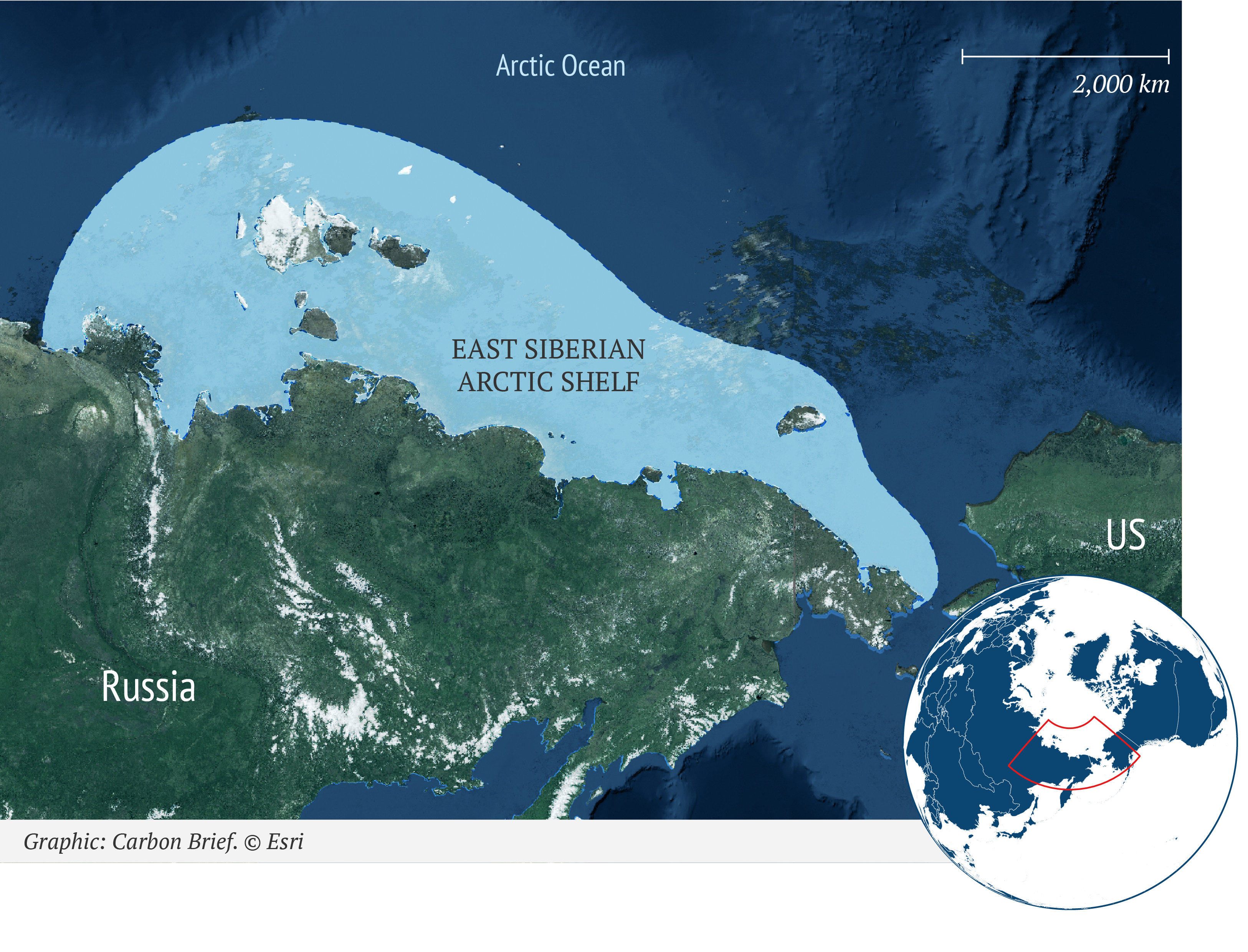
Related to permafrost are methane hydrates, or “clathrates”. This is an ice-like substance formed when methane and water combine at low temperatures and moderate pressure. It is almost exclusively found under the seafloor on continental shelves – areas of seabed immediately surrounding a land mass, where the sea is relatively shallow compared to the open ocean beyond it.
Methane hydrates have been central to claims in recent years of a potential “methane bomb” in the Arctic. The theory suggests that ocean warming could melt these ice crystals, releasing vast amounts of methane into the atmosphere.
A few years ago, for example, scientists identified “widespread seepage of methane from seafloor sediments offshore Svalbard”, which they said “may, in part, be driven by hydrate destabilisation” due to ocean warming. Research also suggested that there were “ready to release” deposits of hydrates in the East Siberian Arctic Shelf (ESAS) under the Arctic Ocean – containing as much as 1,400bn tonnes of carbon. The size of this estimate has been questioned by other scientists.
(For comparison, global emissions from fossil fuels and industry in 2019 amounted to around 10bn tonnes of carbon.)

Arctic Ocean
2,000 km
East Siberian
Arctic Shelf
US
Russia
Graphic: Carbon Brief. © Esri
However, more recent research has poured cold water on the idea of methane hydrates as an impending tipping point. A review paper in 2016, for example, concluded that there was “no conclusive proof that hydrate-derived methane is reaching the atmosphere now”. Methane released at the seafloor “only rarely survives the trip through the water column to reach the atmosphere”, notes a Nature Education Knowledge, because it is oxidised by bacteria in the water.
Indeed, any bubbles of methane coming from the seafloor are more likely to be coming from permafrost than hydrates, adds Armstrong McKay:
“It has been suggested that methane bubble plumes detected in shallow Arctic seas are from destabilising methane hydrates, but most scientists believe that most of this methane is actually from submerged permafrost which has been gradually decaying since the last glacial maximum, but may be gradually accelerating now.”
In addition, while permafrost soils are in direct contact with a warming atmosphere, methane hydrates occur in sediments at great depths below the seafloor. As a result, research indicates that it will “barely be affected by warming over even 10,000 years”.
Overall, “this makes permafrost thawing the bigger concern to us now”, concludes Armstrong McKay, “with most methane hydrates likely to remain relatively stable over the next few centuries”.
Coral reef die-off
Coral reefs are often cited as one of the ecological systems most sensitive to global warming. As a paper published in Science in 2007 puts it:
“Atmospheric CO2 concentration is expected to exceed 500 parts per million (ppm) and global temperatures to rise by at least 2C by 2050 to 2100, values that significantly exceed those of at least the past 420,000 years during which most extant [i.e. existing] marine organisms evolved.”
Recent years have seen a series of “mass bleaching” events in warm water corals, caused primarily by prolonged exposure to high sea temperatures. Under continued heat stress, corals expel the tiny colourful algae living in their tissues – known as zooxanthellae – leaving behind a white skeleton.
The algae provide the corals with energy through photosynthesis. Without them, the corals can slowly starve. Although corals can reacquire their zooxanthellae if conditions turn more favourable, persistent thermal stress can kill off the coral communities of entire reefs.

Mass coral-reef bleaching events have become five times more common worldwide over the past 40 years. The first global mass-bleaching event was recorded in 1998. This has been followed by the second and third in 2010 and 2014-17, respectively. These events were caused by marine heatwaves – extended periods of unusually high temperatures that were themselves boosted by human-caused warming and El Niño.
The map below, from the IPCC’s special report on the ocean and cryosphere in a changing climate (“SROCC”), shows how coral reefs around the world were affected in 2015-16. The shading on the map indicates the annual maximum “degree heating week” (DHW) over 2015 and 2016. (DHW is a measure of cumulative heat stress that “describes how much heat has accumulated in an area over the past 12 weeks by adding up any temperatures that exceed 1C above the maximum summertime mean”.) The dots highlight reefs that experienced severe (purple), moderate (mauve) and no substantial (white) bleaching.

Map shows the Degree Heating Week (DHW) annual maximum over 2015 and 2016. Symbols indicate where severe bleaching affected more than 30% of corals (purple dots), moderate bleaching affected less than 30% of corals (mauve dots) and no substantial bleaching was recorded (white dots). Source: IPCC SROCC (2019) Fig 6.3
Thermal stress is not the only threat to coral reefs. They are also at risk from other factors, including overfishing, destructive fishing practices, sedimentation associated with sea level rise, runoff of nutrients from the land, storm damage, ocean acidification and shifts in ocean circulation.
This lethal cocktail has already seen “persistent shifts from the original dominance by corals to a preponderance of fleshy seaweed or other weedy assemblages” in coral reefs around the world, says a review paper from 2010.
Fast-growing tropical macroalgae can quickly takeover dead coral skeletons, potentially preventing them from being recolonised by corals and leaving them in an altered, albeit stable, state. These shifts can be rapid, says a 2016 study in Scientific Reports:
“Coral reef ecosystems have been observed to undergo dramatic and sometimes abrupt shifts in community state from one dominated by reef-forming coral to one where other space holders predominate. The alternative space holder often, but not always, is fleshy macroalgae.”
Such transitions “have been observed on tropical reefs worldwide, and particularly in the Caribbean”, the study adds. It is typical of ecosystems to show “threshold, rather than linear, responses to slowly building drivers of change such as fishing pressure, added nutrients and rising global temperatures”, says another review paper.
For example, after the 1998 mass-bleaching event, average coral cover in the Cousin Island marine reserve in the Seychelles declined to less than 1% by 2005, while macroalgae cover increased by as much as 40%.

Coral reef overgrown with macroalgae in the Caribbean. Credit: imageBROKER / Alamy Stock Photo.
It is worth noting that heat stress has the same destructive effect on seaweed, such as kelp, in temperate systems, says Dr Maria Beger, an academic fellow in marine conservation science at the University of Leeds. She tells Carbon Brief:
“They then also get replaced by macroalgae and/or corals – this is called ‘tropicalisation’ of higher latitude temperate reefs. What both have in common is that the habitat engineering species are being killed.”
The loss of herbivorous fish from overfishing can be a particular driver of coral reef decline, says Dr Mark Eakin, coordinator of the US National Oceanic and Atmospheric Administration’s Coral Reef Watch programme. He tells Carbon Brief:
“While ecologically intact reefs can bounce back from events such as hurricanes or even severe bleaching, when they lack their herbivores they just can’t bounce back.”
A 2007 study explains that herbivores “play an important role in promoting reef resilience and in reef recovery” by removing algae. Thus, they are crucial for a reef returning to a “coral dominated states if disturbance has occurred”.
However, the study also warns that it is “naive to assume that the protection of herbivorous species…will result in the reversal of a phase shift once macroalgae have become established”. This is because “most herbivorous fishes avoid macroalgae”, the authors say.
The key here is to have healthy numbers of herbivores that “can graze the algae and thus prevent their establishment”, Beger adds. It is once the algae are big that they are less likely to be eaten, she tells Carbon Brief:
“What we consider as normal coral reef herbivores mostly eat the filamentous algae that establish first once a coral is dead. Once the algae establish past being tiny, they are less palatable.”
Other factors can also affect how well a reef recovers after bleaching. A 2015 Nature study of the Seychelles after the 1998 bleaching event found that, of 21 reefs studied, 12 recovered and “nine reefs underwent regime shifts to fleshy macroalgae”. It explains:
“Recovery was favoured when reefs were structurally complex and in deeper water, when density of juvenile corals and herbivorous fishes was relatively high and when nutrient loads were low.”
Recovery still depends on there being sufficient time for corals to reestablish themselves. A healthy reef can “bounce back in 10-15 years” after bleaching, says Eakin, with “regrowth of rapidly growing corals”. However, “many reefs have shown little to no recovery after severe mortality events”, he adds:
“In a recent paper, we showed that severe bleaching occurred every 25-30 years in the 1980s. Now it recurs in less than six years. That is far too fast when 10-15 years to start recovery is the best case scenario.”
A review study, published in Science in 2007, concluded that atmospheric concentrations “above 500ppm appears extremely risky for coral reefs and the tens of millions of people who depend on them directly, even under the most optimistic circumstances”. CO2 levels have already surpassed 410ppm and are projected to exceed 500ppm by 2100 in all but the most stringent mitigation scenarios for emissions this century.
In 2016, the first study to compare the widespread impacts of climate change at 1.5C and 2C of warming warned that 90% of tropical reefs would be “at risk of severe degradation due to temperature-induced bleaching from 2050 onwards” in a 1.5C warmer world. For 2C, this risk rose to 98% of reefs, the study says, indicating that the extra 0.5C of warming “is likely to be decisive for the future of tropical coral reefs”.
The study notes:
“Our analysis reiterates earlier findings that the risk of coral reefs to suffer from long-term degradation eventually leading to an ecosystem regime shift will be substantial as early as 2030.”
The researchers even note that their findings are likely to be “rather conservative” because they only consider the impacts of rising CO2 and not other coral reef stressors.
The findings of the IPCC’s special report on 1.5C are only very slightly less bleak. It says:
“Even achieving emissions reduction targets consistent with the ambitious goal of 1.5C of global warming under the Paris Agreement will result in the further loss of 70-90% of reef-building corals compared to today, with 99% of corals being lost under warming of 2C or more.”
As experts in Australia told Carbon Brief last year, some of the more heat-resistant corals may be more resilient than these estimates suggest, but what the remaining reefs “will look like – and what the consequences will be for the other reef inhabitants, such as fish – remains to be explored”.
Eakin says “we’ve already reached” a tipping point for corals on a global basis because of climate change:
“We are already seeing severe bleaching around the world and the recent 2014-17 global coral bleaching event has been devastating for many reefs around the world. For example, the Great Barrier Reef lost half of its corals in just two years.”
A 2018 Nature paper describes the recent bleaching as “a watershed for the Great Barrier Reef, and for many other severely affected reefs elsewhere in the Indo-Pacific Ocean”.
The study warns that “the most likely scenario” is that “coral reefs throughout the tropics will continue to degrade over the current century until climate change stabilises, allowing remnant populations to reorganize into novel, heat-tolerant reef assemblages”.
The 2016 marine heatwave “has triggered the initial phase of that transition on the northern, most-pristine region of the Great Barrier Reef”, the study says, “changing it forever as the intensity of global warming continues to escalate”. It concludes:
“The large-scale loss of functionally diverse corals is a harbinger of further radical shifts in the condition and dynamics of all ecosystems, reinforcing the need for risk assessment of ecosystem collapse, especially if global action on climate change fails to limit warming to 1.5-2C.”
The widespread loss of coral reefs would be devastating for ecosystems, economies and people. According to the International Union for Conservation of Nature (IUCN), “despite covering less than 0.1% of the ocean floor, reefs host more than one quarter of all marine fish species”. Coral reefs also “directly support over 500 million people worldwide, who rely on them for daily subsistence, mostly in poor countries”, the IUCN adds.
Indian monsoon shift
India receives around 70% of its annual rainfall during the monsoon season. For some areas of western and central India, it accounts for as much as 90%. The monsoon rains are crucial for India’s farm sector, which makes up about a sixth of India’s economy and employs about half of the country’s 1.3 billion population.
The Indian monsoon – also known as the South Asian monsoon – is a sub-system of the wider Asian monsoon, along with the south-east Asian monsoon and the western North Pacific monsoon. (Some consider the Asian monsoon to have more than three parts.)
The word “monsoon” originates from the Arabic word for season. It describes a seasonal shift in winds – specifically a 180-degree reversal that triggers the change from the dry to the wet season.

A storm hits Old Delhi during the Indian monsoon season. Credit: GoSeeFoto / Alamy Stock Photo.
This shift is driven by the movements of the sun through the seasons, explains Dr Andrew Turner, associate professor in monsoon systems at the University of Reading. In the northern hemisphere winter, the focus of the sun’s energy is over the southern hemisphere. This causes a prevailing wind over India from the north-east, bringing dry air from across the Asian landmass.
The transition to the wet season arrives as the sun moves north of the equator in spring and early summer. Here, “northern India, the Tibetan Plateau and surrounding regions heat up rapidly”, Turner explains to Carbon Brief:
“They heat up more quickly than nearby oceans – for example, the northern Indian Ocean – since land (soil) has a much lower heat capacity than water.”
The contrast in heating between the land and ocean causes a pressure gradient that drives southwesterly winds across India. “This air travels northward from the Indian Ocean,” says Turner, picking up moisture as it goes. The rains typically begin in June – the official start date of the monsoon season is 1 June – moving north through India. The rains continue until the monsoon starts to withdraw from northern India by the end of August, as the strength and duration of the summer sun decreases. The rains then peter out for most of the country through September and October.
The maps below show the average monsoon onset (left) and withdrawal (right) dates across India.

Average dates of onset and withdrawal of the monsoon. Reprinted by permission from Springer. Gadgil (2018) The monsoon system: Land–sea breeze or the ITCZ?, Journal of Earth System Science.
“At a fundamental level, the pressure gradient between the Indian Ocean and Asian continent determines the strength of the Asian monsoon”, says the IPCC’s special report on 1.5C. And so, in theory, “anything which alters either the north-south temperature gradient, or the amount of moisture evaporated from the ocean, could change the monsoon rains”, notes Turner.
With land areas warming faster than oceans, a strengthening of this pressure gradient and the monsoon itself “may be expected under global warming”, says the 1.5C report. In addition, as a warmer atmosphere can hold more moisture, this may also result in “modest increases in rainfall”, says Turner.
However, a review study in 2012 – led by Turner – concludes that “the evidence for such trends in observations is unpersuasive”. While the observed record for the strength of the Indian monsoon shows a lot of variability, it does “suggest a negative trend since 1950”, the paper says. This amounts to a rainfall decline of around 10% in central India, adds Turner.
A potential cause could be air pollution – from India itself and the wider region, Turner says:
“Air pollution comes in several forms, but most of it is in the form of sulphur compounds – for example, emissions of sulphur dioxide from industry and transport – that form sulphates in the atmosphere. These particles have reflective properties, which act to reflect solar radiation and prevent some of it reaching the surface.”
This pollution “will preferentially cool the northern hemisphere region over Eurasia relative to the equator or southern Indian Ocean – where there are no pollution emissions”, says Turner. Increasing trends in air pollution in South Asia could explain “why seasonal mean rainfall over India has not shown increases in the recent observed record despite increasing CO2”, his paper says. Another study says the aerosol cooling in South and East Asia “may have masked up to 1C of greenhouse-gas-induced surface warming since the pre-industrial era”.
The mix of influences resulting from human activity is one of the reasons that making projections for the monsoon is tricky. Another is that climate models can struggle to simulate the monsoon system, in part because of the intricate interplay of circulation, temperature and topography that drives it.
Some papers have suggested the possibility for more abrupt changes in the Indian monsoon. A 2005 study, for example, used a simple model to identify the possibility of the monsoon having two stable states: wet (as it is now) and second state characterised by low rainfall.
Key to these two states is the so-called “moisture‐advection feedback”. This, the paper explains, is where “the land‐to‐ocean pressure gradient, which drives the monsoon circulation, is reinforced by the moisture the monsoon itself carries from the adjacent Indian Ocean”.
In other words, a significant factor in maintaining the monsoon is the heat released when the water vapour it holds condenses to form rain. Another paper, published in the Proceedings of the National Academy of Sciences (PNAS) in 2009, suggests this feedback acts as an “internal amplifier” for the monsoon.
The implication is that this feedback magnifies anything that affects the air pressure gradient generated by warm air rising over the Asian landmass. Thus “relatively weak external perturbations” could lead to “abrupt changes” in the monsoon, the PNAS paper says.
The model simulations in the 2005 study suggest how a switch between states could be triggered. This includes cooling of the land surface through large amounts of air pollution, cooling through very low CO2 levels in the atmosphere, or a combination of the two.
Palaeoclimate studies, using “proxy” reconstructions of past conditions, suggest that shifts to a low rainfall monsoon state have occurred in the past in response to changes in how much of the sun’s radiation reaches the Earth’s surface. For example, in the last ice age and during more recent cold periods such as the Little Ice Age.
However, a 2006 study also shows that the albedo changes required to push the monsoon into a dry state – as in the 2005 study – are a long way from modern conditions. Therefore, the authors conclude, “we can be very certain that we will not reach this point in the near future”.
Albedo: This is a measure of how much of the sun’s energy is reflected by a surface. It is derived from the Latin word albus, meaning white. Albedo is measured as a percentage or fraction of the sun’s energy that is reflected away. Snow and ice tend to have a higher albedo than, for example, soil, forests and open water.
Nonetheless, the existence of the “moisture‐advection feedback” is still disputed. In an illustration of how contested the theory of potential abrupt shifts in the Indian monsoon is, PNAS have since published a response to the original 2009 paper, a reply to that response and a reply to that reply.
Dr William Boos, associate professor at the University of California, Berkeley and author of the PNAS response paper, tells Carbon Brief:
“The key phrase here is ‘abrupt shift’ – monsoons may change a lot, but there simply is no evidence for them being here one year and gone the next in response to human-induced climate change.”
The “vast majority of studies on abrupt changes in monsoons focus on changes that are ‘abrupt’ relative to the past evolution of the climate system that occurred over tens of thousands to millions of years”, adds Boos:
“Palaeo changes are important, but their relevance to human-caused climate change is unclear; feedbacks that take hundreds to thousands of years to operate – involving large changes in ice sheets or continental vegetation and soil types – may not be relevant if we are interested in changes taking place over a few years or a few decades.”
Prof Anji Seth, who leads a physical climate research group at the University of Connecticut, agrees that “there is no evidence that there is a tipping point where you would go from a wet monsoon to a threshold of very dry”. She tells Carbon Brief:
“All the evidence from proxy data in the past shows that when there is less insolation [incoming solar radiation], less radiative forcing, the monsoons are weaker, and when there’s more, they’re stronger – but it’s a very linear relationship. There are no thresholds seen where there are two stable states in the monsoon.”
Overall, the IPCC’s 1.5C report concludes that there is “low confidence” in any projected changes in the Indian monsoon under warming of 1.5-2C, but that increases in the intensity of monsoon rainfall are “likely” in a 3C warmer world.
For the IPCC’s fifth assessment report (“AR5”), published in 2013, all the models assessed “project an increase in mean precipitation as well as its interannual variability and extremes” (pdf), the report says.
While for monsoon systems more generally, the AR5 summary for policymakers (pdf) says:
“Globally, it is likely that the area encompassed by monsoon systems will increase over the 21st century. While monsoon winds are likely to weaken, monsoon precipitation is likely to intensify due to the increase in atmospheric moisture. Monsoon onset dates are likely to become earlier or not to change much. Monsoon retreat dates will likely be delayed, resulting in lengthening of the monsoon season in many regions.”
Greenland ice sheet disintegration
The Greenland ice sheet is the second largest mass of ice on Earth. It holds enough water to raise global sea levels by 7.2 metres and, as a result, its disintegration would change the shape of the world’s coastlines.

Melting of the Greenland ice sheet is accelerating and it is currently adding around 0.7mm to global sea levels each year.
A tipping point for Greenland ice melt is unlikely to be abrupt, says climate scientist Dr Ruth Mottram of the Danish Meteorological Institute, but it is clear that there will be a threshold beyond which its eventual collapse is irreversible.
Around half of the melt that the Greenland ice sheet experiences occurs at the surface. The remainder occurs through melting at the ice sheet base and via the breaking off, or “calving”, of icebergs from its edge.
Surface melt is likely to involve a number of different self-reinforcing feedback loops that can speed up melting, explains Mottram. She tells Carbon Brief:
“Probably the most important ‘tipping point’ feedback though are elevation feedbacks – as the ice sheet gets lower via melting, more are areas are at lower and warmer altitudes, leading to further melting.”
In the clip below, Dr Ricarda Winkelmann of PIK outlines the processes involved in a tipping point for the Greenland ice sheet.
Also important is the “snowline” – the elevation at which the ice sheet is covered in snow. Bright white snow has a higher albedo than dark, bare ice – which means it reflects back much more of the sun’s energy. So if the snowline migrates to higher elevations as the ice sheet warms, it means the ice will be absorbing more of the incoming solar radiation, causing more melting.
Research published in 2019 found that snowline migration accounted for more than half of the year-to-year variations in how much of the sun’s energy was available for melting.
In addition, as meltwater trickles down into the snowpack, it fills the pores in the snow and gives off more heat when it refreezes. This “makes it harder for the snowpack to hold further meltwater, so any additional meltwater will run off directly into the sea”, Mottram says.
The combination of these processes means that a tipping point in Greenland ice melt is “very much related to how much melting is happening at the surface and how much of a snowpack there is to absorb that meltwater”, says Mottram. This has “cascading consequences as the meltwater can affect ice sheet flow speeds and calving processes”.
The lPCC’s most recent full assessment report – AR5, published in 2013 – concluded that (pdf) it is “exceptionally unlikely” that the Greenland ice sheet will suffer near-complete disintegration in the 21st century – equivalent to a 0-1% likelihood of it happening.
However, more recent research suggests that the ice sheet is at risk on longer timescales. A review paper in Nature Climate Change in 2018 concluded that 1.8C (with a range of 1.1-2.3C) of warming above pre-industrial levels would be enough to trigger feedback loops of decline in parts of the ice sheet in summer.
This could set in motion a pattern of melt that takes thousands of years, the paper concluded:
“Thus, crossing the limit of 1.5C global warming this century may impose a commitment to much larger and possibly irreversible changes in the far future.”
The IPCC’s special report on 1.5C – published in 2018 – noted that a “useful indicator” for the elevation feedback mentioned above is the “threshold at which annual mass loss from the ice sheet by surface melt exceeds mass gain by snowfall”.
(This means a negative surface mass balance (SMB) over the course of the year. As an example, the SMB for 2019 was 169bn tonnes of ice, the seventh lowest on record. Total mass balance – which includes the ice lost through calving and ocean melt – switched from overall gains to overall losses between the 1970s and 1980s.)
The most recent studies suggest that this threshold “sits between 0.8C and 3.2C, with a best estimate at 1.6C”, the special report says, adding:
“The continued decline of the ice sheet after this threshold has been passed is highly dependent on the future climate and varies between about 80% loss after 10,000 years to complete loss after as little as 2000 years (contributing about six metres to sea level rise).”
The fate of the Greenland ice sheet is, therefore, still strongly dependent on the rate of greenhouse gas emissions in future. A 2019 modelling study published in Science simulated the Greenland ice sheet out to the year 3000 under different emissions scenarios. It found:
“In a thousand years, the Greenland ice sheet will look significantly different than today. Depending on the emission scenario, the Greenland ice sheet will have lost 8 to 25% (RCP2.6), 26 to 57% (RCP4.5), or 72 to 100% (RCP8.5) of its present-day mass, contributing 0.59 to 1.88 metres, 1.86 to 4.17 metres, or 5.23 to 7.28 metres to global mean sea level, respectively.”
This is illustrated in the maps below, taken from the paper, which show the observed state of the ice sheet (A) and the projected ice cover by the year 3000 under the three different scenarios (B to D). The shading in the maps shows the likelihood of future ice cover, with dark blue areas indicating areas with remaining ice in 16% of model runs, blue for 50% of model runs and white for 84%.

Greenland ice sheet maps showing the observed extent in 2008 (A) and the projected extent in the year 3000 under RCP2.6 (B), RCP4.5 (C), and RCP8.5 (D) across 500 model simulations. Shading indicates likelihood (in percentiles from model simulations) of ice cover remaining by the year 3000: Dark blue (16%), blue (50%) and white (84%). Likelihoods less than the 16th percentile are not shown. Credit: Aschwanden et al (2019) Reproduced under Creative Commons 4.0.
Following a relatively low emissions pathway, such as RCP2.6 – which is consistent with a 1.5-2C warmer world – may, therefore, be regarded as “representing moderate risk, in that it may trigger…irreversible loss of the Greenland ice sheet”, concludes the IPCC 1.5C report.
The IPCC’s special report on the ocean and cryosphere in a changing climate (“SROCC”) also notes that decay of the ice sheet would not be abrupt. It does say, however, that the decay would be “irreversible for millennia” once underway. This is the same phrasing as used in AR5.
While it is possible that the ice sheet could stabilise at some intermediate point during its collapse, it would not regain its previous vast size until the next ice age, says Mottram:
“It is clear from even very early work that the ice sheet is only there because it is already there – if there was no ice sheet in Greenland under today’s climate we would not be able to build it up again. So once it’s gone it’s gone until at least the next glacial period – and we’ll be waiting some tens of thousands of years given current climate change and the slow rate of carbon removal by natural means.”
Boreal forest shift
Boreal forests are found in the cold climates of the northern hemisphere high latitudes. They lie just to the south of the Arctic tundra, where tree growth is restricted by year-round freezing or near-freezing temperatures and a lack of rain.
Known as the “taiga” in Russia, boreal forests are characterised by species that can cope with the cold, such as pine, spruce and larch. They cover vast stretches of North America and northern Europe and Asia.

Evergreen forest in the Canadian Rockies, British Columbia. Credit: Ken Gillespie Photography / Alamy Stock Photo.
Boreal forests are the largest “biome”, or ecosystem, anywhere on the Earth’s land surface and account for 30% of the world’s forests. They are a very important store of carbon. While there is a lot of uncertainty around the precise amount of carbon they hold, estimates suggest it is more than one third of all terrestrial carbon.
And about a third of the boreal biome is underlain by permafrost.

A world map showing the locations of boreal forests. Credit: aroderick / Alamy Stock Vector.
However, the boreal zone, along with the tundra, is warming rapidly – approximately twice as quickly as the global average. Continued temperature rise could generate rapid changes in boreal forests, including dieback. A 2012 study explains:
“Increasingly warm summers becoming too hot for the currently dominant tree species, increased vulnerability to disease, decreased reproduction rates and more frequent fires causing significantly higher mortality, all contribute.”
A 2017 Nature Climate Change review paper concluded that rapid warming and “naturally lower tree species diversity” could put boreal regions at particular risk of natural forest “disturbances” by factors such as drought, fire, pests and disease. When compared to other ecosystems around the world, the study finds that “future changes in disturbance are likely to be most pronounced in coniferous forests and the boreal biome”.
For example, a 2014 study finds that “continued summer warming in the absence of sustained increases in precipitation” brought about a “turning point” around the mid-1990s that “shifted western central Eurasian boreal forests into a warmer and drier regime”. Research also indicates that “rather than showing gradual responses”, boreal ecosystems “will tend to shift relatively sharply between alternative states in response to climate change”.
Prof Scott Goetz from Northern Arizona University, who is science lead on NASA’s Arctic Boreal Vulnerability Experiment (ABoVE), explains to Carbon Brief how disturbances could cause forests to “tip”:
“An example of a tipping point in boreal forests is a situation where an extreme fire event or repeated severe events render the system incapable of regenerating as a forest ecosystem and instead shifts the system to a sparsely wooded or grassland ecosystem.”
This is more likely to occur at the hotter and drier southern margins of the forest, says Goetz. But a “similar tipping point could occur without fire when extreme drought events kill a large proportion of the trees and composition shifts to other species”, he adds. A new modelling study shows these changes will result in much reduced “aboveground” biomass – i.e. all the living biomass above the soil, including branches, bark and foliage.
The IPCC’s special report on 1.5C notes that “increased tree mortality would result in the creation of large regions of open woodlands and grasslands, which would favour further regional warming and increased fire frequencies, thus inducing a powerful positive feedback mechanism”.
As a result, says Dr Brendan Rogers, assistant scientist at the Woods Hole Research Center, “in places that may transition to grasslands, recurring fire regimes may keep the system in a perpetual treeless state”.
At the southern margins of boreal forests, “aspen and spruce species are most at risk”, says Goetz and, therefore, most likely to be replaced:
“Pine species, shrubs and grasses, as well as more temperate tree species – oaks and maples – will be those most likely to fill the gaps the boreal species leave behind, at least in North America. In northern Eurasia, we’d expect pine species to dominate areas of the currently widespread larch forests.”
A 2012 study of forests in Alaska, for example, identified “a widespread shift from coniferous to deciduous vegetation [that] began around 1990 and will continue over the next several decades”.
But while trees at the southern edge of the boreal zone risk dieback, research suggests that forests at the northern edge could move into tundra under climate change. A 2018 modelling study finds that, even if the Paris warming limits are met, “boreal forests are simulated to expand into the tundra, while on the other hand tree composition shifts toward temperate species along their warm edge”.
Under the existing Paris emissions reduction pledges, the study projects “major climate change effects for more than 80% of the tundra and more than 40% of all boreal forests”.
The graphic below, published in the IPCC’s fifth assessment report in 2014, illustrates the factors involved in a northwards shift of the boreal biome into the tundra.

Illustration of the potential tundra-boreal biome shift under a warming climate. Credit: IPCC (2014) WG2 Fig4-10.
There is already evidence of boreal forests shifting. The IPCC’s 1.5C reports concludes that it has “high confidence” that “woody shrubs are already encroaching into tundra and will proceed with further warming”.
It also says that abrupt increases in tree cover are “unlikely” at 1.5-2C of warming. Above 2C of warming, there is “potential” for abrupt increases, the report says – albeit with “low confidence”.
For the boreal biome, the report says there is “medium confidence” of “further increases in tree mortality” at the southern boundary at 1.5C and 2C of warming. While “a drastic biome shift from tundra to boreal forest is possible” beyond 2C, it says there is “low confidence” in this projection.
It further notes that a potential “tipping point has been estimated to exist between 3C and 4C of global warming (low confidence), but given the complexities of the various forcing mechanisms and feedback processes involved, this is thought to be an uncertain estimate”.
Significant changes in boreal forests are made more likely by the rapid rate of warming, says Goetz:
“I don’t know that anyone has put a number on a species-specific tipping point, but we have high confidence that with global temperature increases of 1.5 or 2C, which in the boreal will translate into about double those temperature increases, we will see widespread changes in tree species composition and fire regimes.”
Such changes could occur within decades, he adds:
“Fire frequency and severity is the big factor here. With more severe fires and especially with more frequent severe fires, which burn off the organic soil layer, we’d expect to see a shift in forest species over the next two-to-three decades that would persist for many decades to come.”
Shifts in vegetation cover will affect the reflectivity of the land surface – known as its “albedo”, says Prof Colin Prentice, chair in biosphere and climate impacts at Imperial College London. He tells Carbon Brief:
“Northward expansion of the boreal forest is certainly expected as a result of warming and, indeed, there is evidence that it is happening already. Similarly, shrub tundra is expanding into colder regions as a result of warming and this process will continue…There will be, as a result, a decrease in vegetation albedo – especially in spring – which will amplify the warming locally. This is well attested both from first principles and climate model experiments.”
This “would lead to increased heat absorption in the Arctic and more rapid permafrost thaw”, says Goetz:
“Obviously great permafrost degradation means a lot more carbon emitted to the atmosphere, which would have the effect of increasing the cycle of warming and even more degradation, with global implications.”
Rogers agrees that the change in albedo is a key impact of shifting boreal forests. He tells Carbon Brief:
“We know from palaeoclimate literature that northward forest and tall shrub migration is a major Earth system feedback, mostly because of the darkened surface. This is particularly important in the late winter and spring due to the combination of high snow cover and moderate incoming solar radiation.”
In fact, he adds, “the full extent of ice ages [in Earth’s history] is impossible without this feedback”. For the modern day, “we expect this to be a warming effect, and we’re already witnessing shrubs getting denser and taller, and trees migrating north”, he says.
Carbon emissions from permafrost thaw and dieback of forests at the southern edge of the boreal biome would be a “double-whammy”, says Rogers.
However, the uncertainties in predictive models mean that scientists cannot be sure of when these shifts will happen across boreal forests, notes Rogers. And it is still not clear whether it “represents a true ‘tipping point’ or more of a gradual transition”, he adds:
“Certainly for any one location, there likely exists a tipping point beyond which the forest will be fundamentally altered – and wildfire can facilitate and exacerbate these transitions. But the boreal is a vast zone, with variation in climates and landscapes that may ‘tip’ at different times.”
Prentice argues that a gradual shift is more likely. “There are thresholds,” he notes, in terms of the conditions required for particular tree species to thrive at certain latitudes or elevations. But, he says, “the effect of warming is simply to gradually shift the geographic location of the threshold”.
He also says that neither the northward expansion of boreal forests nor their contraction in the south are likely to be irreversible:
“Cooling would send them into reverse. It is worth noting also that very large shifts in the distribution of the boreal forests have happened in the relatively recent geological past in response to natural climate changes that are reasonably well understood.”
However, Goetz points out that “fire is the wildcard and can shift forests much more rapidly than from warming effects on tree growth alone”. And Rogers adds that while “forest composition may be reversible”, the carbon emitted from thawing permafrost “would take much, much longer” to reaccumulate:
“That carbon took millennia to be sequestered by the land and gradually accumulate in frozen soil layers.”
Other tipping points
The nine tipping points described above do not constitute an exhaustive list – indeed there are a number of other parts of the Earth system that have the potential to display tipping point behaviour.
Some examples include: shutdown of Antarctic bottom water formation; loss of alpine glaciers; a climate change-induced hole in the ozone layer above the Arctic; ocean anoxia (where areas of the ocean see a dramatic decline in oxygen); and a change in the frequency and/or strength of El Niño events.
Another example that is often cited is the decline of Arctic sea ice. Climate model simulations have suggested that summer sea ice extent in the Arctic could see abrupt and accelerating declines during this century. Such a potential decline is associated with the ice-albedo mechanism, explains Dr Dirk Notz, head of the Sea ice in the Earth system research group at the Max Planck Institute for Meteorology. He tells Carbon Brief:
“Less sea ice in one year implies more absorption of solar heat by the ocean, thus more warmth available to melt ice further, thus causing less sea ice the year after.”
The “idea of such a sea-ice tipping point was quite popular perhaps a decade ago”, says Prof Mark Serreze, director of the US National Snow and Ice Data Center (NSIDC). A 2005 paper in the Journal of Climate, for example, asked “Have we passed a tipping point?“ in response to thinning Arctic sea ice between 1988 and 2003.
However, the theory has not been supported by the latest research, Serreze tells Carbon Brief:
“More recent work argues that the trajectory to a seasonally ice-free ocean will be pretty much along the path that we are observing – a downward trend with strong ups and downs from year to year (and over multiple years) reflecting the influences of natural variability.”
Research by Notz and colleagues, for example, has shown that large declines in summer sea ice are reversible. Notz explains:
“After a year with anomalously little sea ice, the sea ice usually recovers somewhat in the year afterwards. This is because in addition to the amplifying ice-albedo feedback, there are dampening feedbacks that stabilise the ice cover from one year to the next.”
For example, less ice in summer means more open water going into winter. Without the insulating effect of the ice, the Arctic Ocean subsequently loses a greater amount of heat, which means it sees more ice growth in winter. In addition, thin ice in winter grows faster than thick ice, giving the chance for some degree of recovery after a small extent in summer.

These feedbacks “imply that the memory of the sea ice cover is largely reset during winter”, says Notz, making the ice loss approximately linear in response to rising greenhouse gases.
However, while sea ice itself might not be a tipping element, ecological systems associated with it might well be, adds Notz:
“If the ice is gone completely in a given summer, any ecosystem that needs the continuous existence of sea ice might be wiped out ‘forever’.”
Another concern around tipping points is the potential for one to trigger a “cascade” effect on others. A Nature commentary from November 2019, for example, argues that “cascading effects might be common” in the Earth system, warning that this would be “an existential threat to civilization”.
It references a 2018 Science paper that assessed 30 different potential social-ecological “regime shifts” and identified links between them in 45% of cases. The study “proposes and investigates” two ways that regime shifts can be linked: domino effects and hidden feedbacks. It explains:
“Domino effects occur when the feedback processes of one regime shifts affect the drivers of another, creating a one-way dependency. Hidden feedbacks rise when two regime shifts combined generate new (not previously identified) feedbacks; and if strong enough, they could amplify or dampen the coupled dynamics.”
Examples of these links “are starting to be observed”, the commentary says:
“Arctic sea-ice loss is amplifying regional warming, and Arctic warming and Greenland melting are driving an influx of fresh water into the North Atlantic. This could have contributed to a 15% slowdown since the mid-twentieth century of the Atlantic Meridional Overturning Circulation (AMOC).”
In addition, rapid Greenland melting and further slowdown of the AMOC could “destabilise the West African monsoon, triggering drought in Africa’s Sahel region”, the authors say, as well as “dry the Amazon, disrupt the East Asian monsoon and cause heat to build up in the Southern Ocean, which could accelerate Antarctic ice loss”.
(Some of the same authors have also suggested that cascading tipping points “could push the Earth system irreversibly onto a ‘Hothouse Earth’ pathway”. The much talked-about paper, published as a perspective in PNAS, concludes that “the risk of tipping cascades could be significant at a 2C temperature rise and could increase sharply beyond that point”. The paper has not been universally welcomed by climate scientists.)
Finally, in addition to the physical tipping points in the Earth system, the term is often also applied to transforming human society in a positive way. Lenton explains:
“I think we also need to be looking at tipping points in human, social and technological systems – this time, tipping points for the good. Cases where a little bit of policy intervention or incentive could tip us onto a path towards a more sustainable future that essentially avoids the worst of the climate tipping points.”
For example, analysts and columnists frequently predict an impending tipping point in the increasing uptake and/or falling cost of electric cars – as sales of traditional cars peak and demand for electric vehicles, and the infrastructure to support them, takes hold.
A groundswell of demand can push a behaviour, product or technology from the fringe and into the mainstream, often as a result of falling prices. An article published in January this year by the thinktank Carbon Tracker, for example, described how a “political tipping point is coming” on renewable power generation:
“The falling costs of renewables are driving a political tipping point where politicians move from expensive support for renewables to embrace the sector and to tax fossil fuel externalities.”
There are tipping points across society that could lead to a rapid global transformation, recent research in Proceedings of the National Academy of Sciences (PNAS) argues. For example, the study identifies six “social tipping interventions” that could help lead to a carbon-neutral society by 2050:
“These social tipping interventions comprise removing fossil-fuel subsidies and incentivising decentralised energy generation, building carbon-neutral cities, divesting from assets linked to fossil fuels, revealing the moral implications of fossil fuels, strengthening climate education and engagement, and disclosing greenhouse gas emissions information.”
While the term “tipping point” is often applied quite loosely regarding political and societal change, it is clear that a number of them will need to be crossed – and quickly – to avoid toppling those in the Earth system.
The post Explainer: Nine ‘tipping points’ that could be triggered by climate change appeared first on Carbon Brief.


