

 2017-09-06 20:23:37 UTC
Hurricane Irma is rewriting meteorological history as it tears across the Caribbean, swallowing islands in the process, destined for a not-so-welcome rendezvous with the Southeast coast of the U.S.
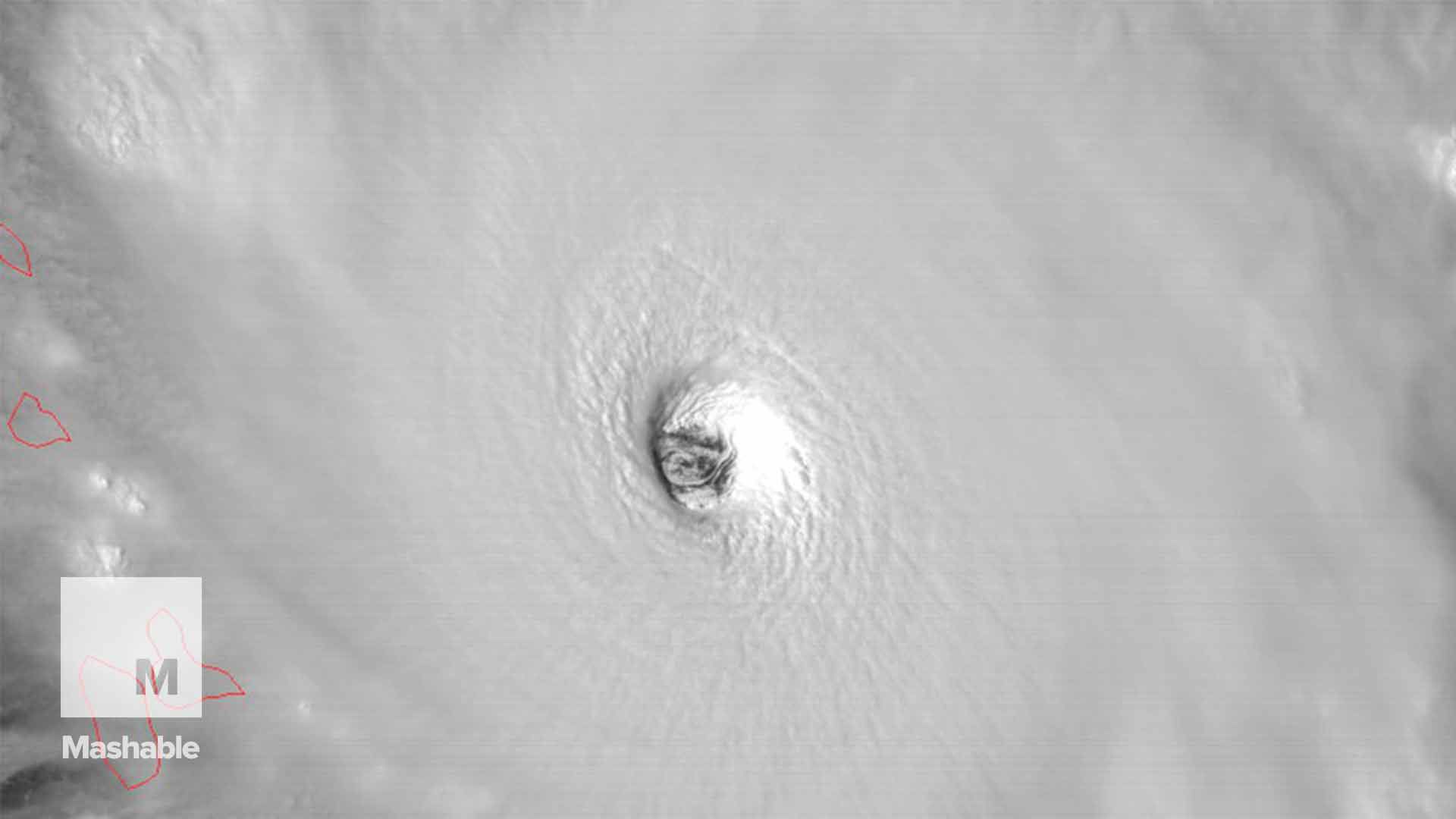
The storm is tied for the 2nd-most intense hurricane on record in the Atlantic, and has kept up an astonishing intensity — featuring maximum sustained winds of 185 miles per hour — for more than 24 hours straight.
Until Irma, only Hurricane Allen in 1980 stayed at that intensity for nearly as long — 18 hours, according to hurricane researcher Philip Klotzbach of Colorado State University. No eastern Pacific storm has accomplished this feat either.
Meteorologists have been monitoring Hurricane Irma with a mix of awe and dread as the storm has intensified and continued its rapid pace, spreading destruction from Barbuda to Puerto Rico on Wednesday, and expected to continue all the way into the U.S. mainland.
For the weather obsessed among us, monitoring Irma has been like watching an elite sprinter as they break a record time that no one thought was beatable. From a purely meteorological standpoint, Hurricane Irma is a startling example of one of nature’s most powerful storms at or near its peak potential.
It’s no accident that Hurricane Irma has become so intense and stayed this way.
Simply put, the hurricane hit the jackpot by being born into, and continuing to move through, an environment supportive of a monster storm. Hurricanes may be nature’s most powerful storms, but they are often remarkably fickle beasts. Rarely do they maintain extraordinarily high intensities for very long, instead getting tripped up by internal cycles or conditions external to them, such as cool ocean temperatures or strong upper level winds.
So far, Irma has hit nothing but perfect conditions for its intensification.
First, there’s the ocean’s temperature. The ocean waters from near the Lesser Antilles to the Florida Keys are incredibly warm, partly because they’re near the typical annual peak for the season. The waters are also unusually mild for this time of year, too, partly owing to climate change, which is causing air and sea temperatures to increase around the world.
The mild waters in these areas extend well below the surface, offering plenty of ocean heat to nurture a beast like Irma, since this prevents its violent winds from churning up a huge amount of colder water, thereby weakening it.
Unfortunately, the ocean heat content ahead of Hurricane Irma is off the charts, making its maximum potential intensity above 200 miles per hour. However, other factors are forecast to limit the storm’s intensification, and in fact the National Hurricane Center is calling for slow but steady weakening — to a Category 3 or 4 storm — by the time it nears or makes landfall in Florida this weekend.
“The ocean heat content has been very high, along with sea surface temperatures, and so the upwelled cold wake is not as cold as it might be, [this is] a climate change effect,” said Kevin Trenberth, a senior researcher at the National Center for Atmospheric Research, in an email.
“The tracking over ‘new’ water helps,” Trenberth said, referencing the storm’s relatively rapid movement over waters that have not been churned up by another storm this year so far.

Storm maximum potential intensity maps for the region where Hurricane Irma is moving. Note the peak in potential intensity between South Florida and Cuba.
Image: kerry emanuel/mit
Next, there’s the atmospheric conditions that Hurricane Irma has been lucky enough to respond to. There is extremely low amounts of wind shear over the Caribbean right now, and the storm is forecast to maintain its “major” hurricane status for the next 5 days — which would be a remarkable, and potentially devastating, run.
Storms like Hurricane Irma suck in vast amounts of warm, humid air from near the ocean surface, and vault it high into the sky in the form of convective towers that reach into the stratosphere. From there, the air must go somewhere, or the storm starts choking on itself. A network of outflow channels move that air up to a one thousand miles away in all directions, and if one of these channels is blocked by wind shear, dry air, or another weather system, the storm’s intensity will usually decrease.
In the case of Hurricane Irma, the outflow conditions have been ideal.
Lastly, there’s Hurricane Irma’s structure, which is also ideal for resisting weakening trends that often trip up other intense hurricanes. The storm is large, and has often exhibited a dual eye wall structure, with two areas of incredibly intense winds encircling the eye, shaped like two rings. Such large storms are known as annular storms, and they can withstand hostile conditions that smaller, more compact hurricanes might have difficulty coping with.

Hurricane Irma as seen from the Suomi NPP satellite, illustrating the outflow channels around the storm.
Image: nasa
And finally, there’s the elephant in the room, which must be acknowledged. In some ways, Hurricane Irma is a storm that allows us to picture what global warming looks like.
Climate change is probably playing some role in the storm’s monstrous intensity, thanks to higher ocean temperatures and atmospheric moisture levels, both of which provide fuel for storms like Irma. However, the magnitude of the role played by human emissions of greenhouse gases in boosting Irma’s power is unclear — is it responsible for 5 miles per hour of these winds, or 20? So far, no clear global warming signal has emerged in hurricane intensity trends in the Atlantic Ocean, in part because of the limitations in hurricane data across the region.
However, climate scientists generally expect future storms to be more intense and drop more rain than hurricanes typically have in the past. That’s why Hurricane Harvey, which made landfall on August 25, is such a suspicious storm in the eyes of climate scientists, having produced the most extreme rainstorm in the country’s history.

Hurricane Irma
Image: CIRA/RAMMB
According to a recent statement from a World Meteorological Organization’s expert team on how climate change is altering tropical cyclones, there is evidence supporting the link between Harvey’s rains and global warming. In addition, the statement said, model studies show that “… hurricanes in a warmer climate are likely to become more intense,” and that major hurricanes of Category 3 or greater are likely to become more common, even if overall storm numbers decline.
“Such changes are not yet clearly detectable in observed data due in part to limitations of existing datasets,” the statement concluded.
The clearest way that Hurricane Irma will interact with global warming is when it makes landfall, since sea level rise from climate change exacerbates storm surge flooding. Some areas that are in the forecast path of the storm, such as South Florida, Georgia, and the Carolinas, are particularly vulnerable to such flooding.
.


