

Whenever hurricane season arrives in the Atlantic Ocean — typically between June and November — a bunch of meteorological terms get hurled around. Tropical storm. Tropical depression. Category 3 hurricanes. Category 4 hurricanes.
So what’s the difference between all these types of weather events? One way to understand this is to walk through the different stages of a hurricane, step by step. We’ll use Hurricane Irma, which started out as a wave off the African coast and is currently pounding several Caribbean as it heads toward Puerto Rico, as an example:
1) Tropical disturbance: A hurricane in the Atlantic Ocean typically begins life as a lowly “tropical disturbance” — defined as organized thunderstorm activity that stretches at least 100 miles across and maintains its identity for more than 24 hours.
During the summer, these disturbances often start as storms moving westward off the coast of Africa in what are known as “tropical waves.”
If meteorologists think a tropical disturbance may develop further, they’ll designate it as an “investigative area,” or invest. Irma became a disturbance off the Cape Verde Islands in late August, with forecasters keeping close watch as it headed west.
2) Tropical depression or cyclone: Under the right conditions, a tropical disturbance can develop further and start to spin around a low-pressure center. Once that happens, it’s classified as a “tropical cyclone” or “tropical depression”:
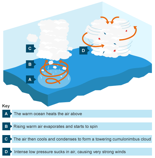
For a tropical depression to form, conditions have to be just right: The water has to be warm enough to fuel the system, with temperatures of 80°F or hotter. There needs to be enough moisture in the lower and middle part of the atmosphere. Local winds also have to be arranged so that they allow the depression to spin — too much wind shear can tear an aspiring tropical cyclone apart.
3) Tropical storm: This is the next stage. When the pressure in the center of the tropical depression drops, air rushes in, creating strong winds. If the system strengthens and wind speeds rise past 39 mph, the system is dubbed a “tropical storm” and is given a name. That’s what happened to Irma on August 30, as it picked up speed in the far Eastern Atlantic and intensified.
The US National Hurricane Center makes the call for when a tropical depression officially becomes a tropical storm. It relies on data from islands and buoys as well as from reconnaissance aircrafts that fly into the storms to measure wind speed.
4) Hurricane: Tropical storms can intensify quickly if they pass over a region of especially warm water and don’t face much wind shear. As that happens, the pressure in the center drops even further and the winds really pick up. The system gets rounder and often forms a clearly defined “eye.” Here’s Irma on Wednesday:
When the winds reach sustained speeds of 74 mph or more, the storm system is classified as a hurricane. Hurricanes are categorized according to the Saffir-Simpson Scale based on their wind speed and propensity for damage.

Irma was a Category 5 as of Tuesday with wind speeds of 185 miles per hour. That’s serious — major hurricanes can do structural damage to buildings, take down trees, and cause widespread flooding.
Side note: The fact that you need especially warm water here explains why hurricanes only form in the Atlantic during the late summer months. (It also helps explain why global warming may lead to stronger hurricanes, although this gets complicated, since climate change can also affect wind shear that suppresses hurricanes.)
5) Back down to tropical storm: Hurricanes can also weaken, however, as they move over land (or cooler water) and no longer have warm, moist air to fuel them. Once wind speeds drop below 75 miles per hour, the hurricane gets downgraded to a tropical storm — and, later on, a “post-tropical cyclone” as it degrades further.
For example, Hurricane Hermine in 2016 was downgraded to a tropical storm not long after it made landfall in Florida in September. But then Hermine moved back over the Atlantic Ocean and hit record-warm ocean temperatures there, gathering to hurricane strength again.
It’s worth emphasizing that even tropical cyclones that aren’t hurricanes can still do a great deal of damage by bringing torrential rain, dangerous surf, beach erosion, high winds, and flooding. In 2012, “superstorm” Sandy was technically no longer a hurricane when it hit the East Coast, but it still proved devastating to the New York and New Jersey coasts.
Read more: Hurricane Irma is one of the most powerful Atlantic hurricanes ever: what we know


