
 2017-04-26 19:46:08 UTC
Until recently, it seemed that we would be able to manage global warming-induced sea level rise through the end of the century. It would be problematic, of course, but manageable, particularly in industrialized nations like the U.S.
However, troubling indications from the Greenland and Antarctic Ice Sheets show that melting is taking place faster than previously thought and that entire glaciers — if not portions of the ice sheets themselves — are destabilizing. This has scientists increasingly worried that the consensus sea level rise estimates are too conservative.
With sea level rise, as with other climate impacts, the uncertainties tend to skew toward the more severe end of the scale. So, it’s time to consider some worst-case scenarios.
Recently, the National Oceanic and Atmospheric Administration (NOAA) published an extreme high-end sea level rise scenario, showing 10 to 12 feet of sea level rise by 2100 around the U.S., compared to the previously published global average — which is closer to 8 feet — in that time period.
The research and journalism group Climate Central took this projection and plotted out the stark ramifications in painstaking, and terrifying, detail.
The bottom line finding?
“By the end of the century, oceans could submerge land [that’s] home to more than 12 million Americans and $2 trillion in property,” according to Ben Strauss, who leads the sea level rise program at Climate Central.
Here’s what major cities would look like with so much sea level rise:

New York City
Image: CLIMATE CENTRAL

New Orleans: Gone.
Image: CLIMATE CENTRAL

San Francisco International Airport
Image: CLIMATE CENTRAL

Bienvenido a Miami.
Image: CLIMATE CENTRAL
In an online report, Climate Central states that the impacts of such a high amount of sea level rise “would be devastating.”
For example, Cape Canaveral, which is a crown jewel for NASA and now the private sector space industry, would be swallowed up by the Atlantic. Major universities, including MIT, would be underwater, as would President Trump’s “southern White House” of Mar-a-Lago. In the West, San Francisco would be hard-hit, with San Francisco International Airport completely submerged.
“More than 99 percent of today’s population in 252 coastal towns and cities would have their homes submerged, and property of more than half the population in 479 additional communities would also be underwater,” the analysis, which has not been peer-reviewed, found.
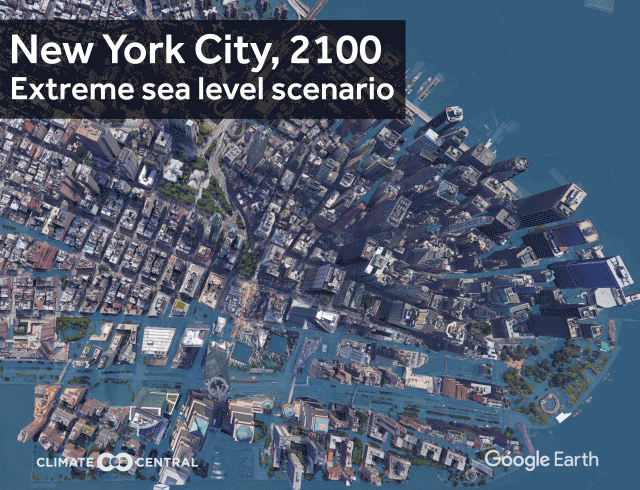
Image: climate central
In New York City, the average high tide would be a staggering 2 feet higher than the flood level experienced during Hurricane Sandy. More than 800,000 people would be flooded out of New York City alone.
Although the findings pertain to sea level rise through the end of the century, in reality sea levels would keep rising long after that, with a total increase of about 30 feet by 2200 for all coastal states, Climate Central found.
As for how likely this extreme scenario really is, here’s what the report says:
“The extreme scenario is considered unlikely, but it is plausible. NOAA’s report and Antarctic research suggest that deep and rapid cuts to heat-trapping pollution would greatly reduce its chances.”
More specifically, the NOAA projection says this high-end outlook has just a 0.1 percent chance of occurring under a scenario in which we keep emitting greenhouse gases at about the current rate.
While a 1-in-1,000 chance outcome might seem nearly impossible to occur, recent events suggest otherwise.
For example, Hurricane Sandy slammed into the Mid-Atlantic in 2012 while following a track that was virtually unprecedented in storm history. In addition, California is estimated to have had just a 1 percent chance of climbing out of its deep drought in a one to two-year period, and it did just that this winter.
Also, Donald Trump is president, people.
Robert Kopp, a sea level rise researcher at Rutgers University, whose projections formed the basis of the NOAA scenarios, said it’s difficult to put exact odds on the extreme scenario.
“I would say that our knowledge about marine ice-sheet instability is too deeply uncertain for us to answer that question right now,” Kopp said in an email. “We can come up with a physically plausible pathway that gets us to 2.5 meters [or 8.2 feet], we know it is more likely under higher emissions, but we don’t have a good way of putting a probability on it.”
A paper published in the journal Nature in March found that if emissions of global warming pollutants peak in the next few years and are then reduced quickly thereafter, then there is a good chance that the melting of the Antarctic Ice Sheet would be drastically curtailed.
However, with the U.S., which is the second-largest emitter of greenhouse gases, backing away from making significant cuts under the Paris Climate Agreement, adhering to such an ambitious timetable is looking less realistic.

Image: climate central
In order for NOAA’s extreme scenario, and therefore Climate Central’s maps, to turn into reality, there would need to be decades more of sustained high emissions of greenhouse gases plus more melting from Antarctica than is currently anticipated.
However, recent studies have raised questions about Antarctica’s stability, as mild ocean waters eat away at floating ice shelves from below, freeing up glaciers well inland to flow faster into the sea.
“What’s new is that we used to think 6- to 7 feet was the max *plausible* or *possible* sea level rise this century, and now we’ve roughly doubled that,” Strauss said in an email. “The new Antarctic science says it’s plausible.”
“If you were to survey ice sheet experts today, instead of something like 5 to 10 years ago, I suspect you’d get a significantly higher probability than 0.1 percent,” he said.
A study published in the journal Nature Climate Change last week found that sea level rise could prompt a wave of internal migration within the U.S., especially as people move from the hardest-hit states such as Florida, Louisiana and New York.
It’s long been known that Florida is ground zero for sea level rise impacts, but the Climate Central projections are even more pessimistic. The report shows that a whopping 5.6 million Floridians would be at risk before the end of the century under an extreme sea level rise scenario, about double the amount simulated in the study last week.


