

Hong Soule and her husband Charles bought their two-story house in Cinco Ranch Equestrian Village for its views of George Bush Park.
Soule, a native of Shanghai, gazed at that vast green space and saw fresh air, playgrounds, soccer fields and a dog park. She didn’t realize this bucolic setting was part of a reservoir – a lake bottom just waiting to fill. It took Hurricane Harvey to make that clear.
During the storm, Soule and her three children were stranded by rising floodwaters in their neighborhood, where people were taken to safety in military trucks.
Soule was among 31,000 property owners in Harris and Fort Bend counties who learned during Harvey’s mass evacuations that their homes lie in what the federal government considers emergency lake beds behind the Barker and Addicks dams. Engineers call them “flood pools.”
Homes in the Cinco Ranch area are surrounded by water from Barker Reservoir, Saturday, September 2, 2017, in Houston. (Mark Mulligan / Houston Chronicle)
Homes in the Cinco Ranch area are surrounded by water from Barker Reservoir, Saturday, September 2, 2017, in Houston. (Mark Mulligan / Houston Chronicle)
Photo: Mark Mulligan, Staff Photographer
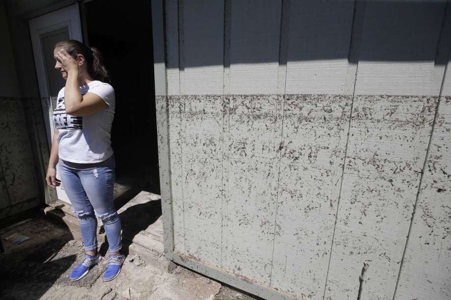
Photo: Melissa Phillip, Staff
Hong Soule learned during Hurricane Harvey evacuations that her family’s home in Cinco Ranch Equestrian Village, as do thousands of other homes, lies in what the federal government calls a “flood pool.”
Hong Soule learned during Hurricane Harvey evacuations that her family’s home in Cinco Ranch Equestrian Village, as do thousands of other homes, lies in what the federal government calls a “flood pool.”
Photo: David Funchess
Sherry Mack spent $100,000 to repair damage and modify her home in Bear Creek Village home after the 2016 Tax Day floods. Mack, 69, can’t swim and uses an electric wheelchair to get around.
Sherry Mack spent $100,000 to repair damage and modify her home in Bear Creek Village home after the 2016 Tax Day floods. Mack, 69, can’t swim and uses an electric wheelchair to get around.
Photo: Melissa Phillip, Staff
Ron Black walks down a flooded street to get to his house after Tropical Storm Harvey Friday, Sept. 1, 2017 in Sienna Plantation.
Ron Black walks down a flooded street to get to his house after Tropical Storm Harvey Friday, Sept. 1, 2017 in Sienna Plantation.
Photo: Michael Ciaglo, Houston Chronicle
A boat sits in a driveway after Tropical Storm Harvey Friday, Sept. 1, 2017 in Sienna Plantation.
A boat sits in a driveway after Tropical Storm Harvey Friday, Sept. 1, 2017 in Sienna Plantation.
Photo: Michael Ciaglo, Houston Chronicle
Mailboxes are inundated by Brazos River flooding along Newlin Drive in Richmond on Friday. Several areas are still dealing with high waters related to Harvey.
Mailboxes are inundated by Brazos River flooding along Newlin Drive in Richmond on Friday. Several areas are still dealing with high waters related to Harvey.
Photo: Michael Ciaglo, Staff
Floodwaters from the Addicks Reservoir inundate a neighborhood off N. Eldridge Parkway in the aftermath of Tropical Storm Harvey on Wednesday, Aug. 30, 2017, in Houston. ( Brett Coomer / Houston Chronicle )
Floodwaters from the Addicks Reservoir inundate a neighborhood off N. Eldridge Parkway in the aftermath of Tropical Storm Harvey on Wednesday, Aug. 30, 2017, in Houston. ( Brett Coomer / Houston Chronicle )
Photo: Brett Coomer, Houston Chronicle
Photo: Karen Warren, Houston Chronicle
Photo: Karen Warren, Houston Chronicle
Photo: Melissa Phillip, Houston Chronicle
Photo: Godofredo A. Vasquez, Houston Chronicle
Photo: Godofredo A. Vasquez, Houston Chronicle
Alen Pogue drags a kayak carrying three pet snakes, leopard gecko, and firearms after returning from his flooded home on Forrest Hollow Drive Wednesday, Aug. 30, 2017, in Baytown, Texas.
Alen Pogue drags a kayak carrying three pet snakes, leopard gecko, and firearms after returning from his flooded home on Forrest Hollow Drive Wednesday, Aug. 30, 2017, in Baytown, Texas.
Photo: Godofredo A. Vasquez, Houston Chronicle
Floodwaters from the Addicks Reservoir inundate a neighborhood off N. Eldridge Parkway in the aftermath of Tropical Storm Harvey on Wednesday, Aug. 30, 2017, in Houston.
Floodwaters from the Addicks Reservoir inundate a neighborhood off N. Eldridge Parkway in the aftermath of Tropical Storm Harvey on Wednesday, Aug. 30, 2017, in Houston.
Photo: Brett Coomer, Houston Chronicle
Columbia Lakes resident Kyle Butler throws sandbags into a truck bed to help shored up wall from overflowing into their subdivision Wednesday, Aug. 30, 2017, in West Columbia.
Columbia Lakes resident Kyle Butler throws sandbags into a truck bed to help shored up wall from overflowing into their subdivision Wednesday, Aug. 30, 2017, in West Columbia.
Photo: Steve Gonzales, Houston Chronicle
Floodwaters fill the road running through the Lakes On Eldridge North subdivision in the aftermath of Tropical Storm Harvey on Wednesday, Aug. 30, 2017, in Houston.
Floodwaters fill the road running through the Lakes On Eldridge North subdivision in the aftermath of Tropical Storm Harvey on Wednesday, Aug. 30, 2017, in Houston.
Photo: Brett Coomer, Houston Chronicle
Photo: Steve Gonzales, Houston Chronicle
Waters levels of Buffalo Bayou have receded near downtown in the aftermath of Tropical Storm Harvey on Wednesday, Aug. 30, 2017, in Houston.
Waters levels of Buffalo Bayou have receded near downtown in the aftermath of Tropical Storm Harvey on Wednesday, Aug. 30, 2017, in Houston.
Photo: Brett Coomer, Houston Chronicle
Floodwaters fill the road running through the Lakes On Eldridge North subdivision in the aftermath of Tropical Storm Harvey on Wednesday, Aug. 30, 2017, in Houston.
Floodwaters fill the road running through the Lakes On Eldridge North subdivision in the aftermath of Tropical Storm Harvey on Wednesday, Aug. 30, 2017, in Houston.
Photo: Brett Coomer, Houston Chronicle
Photo: Karen Warren, Houston Chronicle
Photo: Karen Warren, Houston Chronicle
Photo: Karen Warren, Houston Chronicle
Harris County Sheriff’s Deputy Rick Johnson pauses to listen for people’s voices as they search for people in a neighborhood inundated by water from the Addicks Reservoir, Wednesday, Aug. 30, 2017, in Houston.
Harris County Sheriff’s Deputy Rick Johnson pauses to listen for people’s voices as they search for people in a neighborhood inundated by water from the Addicks Reservoir, Wednesday, Aug. 30, 2017, in Houston.
Photo: Jon Shapley, Houston Chronicle
Tiffany Carroll waits anxiously by the entrance to her neighborhood, where water from the Addicks Reservoir has risen quickly, Wednesday, Aug. 30, 2017, in Houston.
Tiffany Carroll waits anxiously by the entrance to her neighborhood, where water from the Addicks Reservoir has risen quickly, Wednesday, Aug. 30, 2017, in Houston.
Photo: Jon Shapley, Houston Chronicle
Photo: Karen Warren, Houston Chronicle
Photo: Michael Ciaglo, Houston Chronicle
Photo: Michael Ciaglo, Houston Chronicle
Photo: Elizabeth Conley, Houston Chronicle
Photo: Elizabeth Conley, Houston Chronicle
Photo: Elizabeth Conley, Houston Chronicle
Volunteer Paige Atkinson sorts donated clothing at NRG Center, which opened its doors to a capacity of 10,000 evacuees in the wake of Tropical Storm Harvey Wednesday, Aug. 30, 2017 in Houston.
Volunteer Paige Atkinson sorts donated clothing at NRG Center, which opened its doors to a capacity of 10,000 evacuees in the wake of Tropical Storm Harvey Wednesday, Aug. 30, 2017 in Houston.
Photo: Michael Ciaglo, Houston Chronicle
Photo: Melissa Phillip, Houston Chronicle
Photo: Melissa Phillip, Houston Chronicle
Photo: Melissa Phillip, Houston Chronicle
People line up to volunteer at NRG Center, which opened its doors to a capacity of 10,000 evacuees in the wake of Tropical Storm Harvey Wednesday, Aug. 30, 2017 in Houston.
People line up to volunteer at NRG Center, which opened its doors to a capacity of 10,000 evacuees in the wake of Tropical Storm Harvey Wednesday, Aug. 30, 2017 in Houston.
Photo: Michael Ciaglo, Houston Chronicle
Kenny Licona, left, cleans out his flooded out home in the aftermath of Tropical Storm Harvey on Wednesday, Aug. 30, 2017, in Spring, Texas.
Kenny Licona, left, cleans out his flooded out home in the aftermath of Tropical Storm Harvey on Wednesday, Aug. 30, 2017, in Spring, Texas.
Photo: Brett Coomer, Houston Chronicle
A boat runs past houses flooded by Tropical Storm Harvey on Tuesday in Spring. ( Brett Coomer / Houston Chronicle )
A boat runs past houses flooded by Tropical Storm Harvey on Tuesday in Spring. ( Brett Coomer / Houston Chronicle )
Photo: Brett Coomer, Staff
Volunteers man a food and water line at NRG Center, which opened its doors to a capacity of 10,000 evacuees in the wake of Tropical Storm Harvey Wednesday, Aug. 30, 2017 in Houston.
Volunteers man a food and water line at NRG Center, which opened its doors to a capacity of 10,000 evacuees in the wake of Tropical Storm Harvey Wednesday, Aug. 30, 2017 in Houston.
Photo: Michael Ciaglo, Houston Chronicle
A construction crew cleans out Kenny Licona’s flooded out home in the aftermath of Tropical Storm Harvey on Wednesday, Aug. 30, 2017, in Spring, Texas.
A construction crew cleans out Kenny Licona’s flooded out home in the aftermath of Tropical Storm Harvey on Wednesday, Aug. 30, 2017, in Spring, Texas.
Photo: Brett Coomer, Houston Chronicle
People line up to volunteer at NRG Center, which opened its doors to a capacity of 10,000 evacuees in the wake of Tropical Storm Harvey Wednesday, Aug. 30, 2017 in Houston.
People line up to volunteer at NRG Center, which opened its doors to a capacity of 10,000 evacuees in the wake of Tropical Storm Harvey Wednesday, Aug. 30, 2017 in Houston.
Photo: Michael Ciaglo, Houston Chronicle
Photo: Kim Brent, Beaumont Enterprise
A boat runs past houses flooded by Tropical Storm Harvey on Tuesday, Aug. 29, 2017, in Spring.
A boat runs past houses flooded by Tropical Storm Harvey on Tuesday, Aug. 29, 2017, in Spring.
Photo: Brett Coomer, Houston Chronicle
A neighborhood is inundated by floodwaters from Tropical Storm Harvey on Tuesday, Aug. 29, 2017, in Spring.
A neighborhood is inundated by floodwaters from Tropical Storm Harvey on Tuesday, Aug. 29, 2017, in Spring.
Photo: Brett Coomer, Houston Chronicle
Kathryn Loder sorts donated clothing at George R. Brown Convention Center in Houston as Tropical Storm Harvey inches its way through the area on Tuesday, Aug. 29, 2017.
Kathryn Loder sorts donated clothing at George R. Brown Convention Center in Houston as Tropical Storm Harvey inches its way through the area on Tuesday, Aug. 29, 2017.
Photo: Elizabeth Conley, Houston Chronicle
Photo: Elizabeth Conley, Houston Chronicle
A boat lets off people being evacuated from floodwaters left by Tropical Storm Harvey on Tuesday, Aug. 29, 2017, in Houston.
A boat lets off people being evacuated from floodwaters left by Tropical Storm Harvey on Tuesday, Aug. 29, 2017, in Houston.
Photo: Brett Coomer, Houston Chronicle
Photo: Michael Ciaglo, Houston Chronicle
Photo: Michael Ciaglo, Houston Chronicle
Photo: Michael Ciaglo, Houston Chronicle
Kevin Johnston, left, navigates his boat between two flooded houses in the Suminski Park neighborhood as Addicks Reservoir nears capacity Tuesday, Aug. 29, 2017 in Houston.
Kevin Johnston, left, navigates his boat between two flooded houses in the Suminski Park neighborhood as Addicks Reservoir nears capacity Tuesday, Aug. 29, 2017 in Houston.
Photo: Michael Ciaglo, Houston Chronicle
Water inundates a Shell station at Telephone Rd. And south Sam Houston Tollway, Tuesday, Aug. 29, 2017, in Houston.
Water inundates a Shell station at Telephone Rd. And south Sam Houston Tollway, Tuesday, Aug. 29, 2017, in Houston.
Photo: Mark Mulligan, Houston Chronicle
Photo: Marie D. De Jesus, Houston Chronicle
Photo: Godofredo A. Vasquez, Houston Chronicle
Photo: Jon Shapley, Houston Chronicle
Lauren Durst holds onto her ten-month-old son, Wyatt Durst, as they evacuate from the Savannah Estates neighborhood as Addicks Reservoir nears capacity Tuesday, Aug. 29, 2017 in Houston.
Lauren Durst holds onto her ten-month-old son, Wyatt Durst, as they evacuate from the Savannah Estates neighborhood as Addicks Reservoir nears capacity Tuesday, Aug. 29, 2017 in Houston.
Photo: Michael Ciaglo, Houston Chronicle
A high water warning sign on Addicks Satsuma Road is covered by flood waters as Addicks Reservoir nears capacity Tuesday, Aug. 29, 2017 in Houston.
A high water warning sign on Addicks Satsuma Road is covered by flood waters as Addicks Reservoir nears capacity Tuesday, Aug. 29, 2017 in Houston.
Photo: Michael Ciaglo, Houston Chronicle
Photo: Michael Ciaglo, Houston Chronicle
A flares at Shell is shown along with other complexes along 146 Tuesday, August 29, 2017 in Deer Park. Several plants shut down due to Hurricane Harvey.
A flares at Shell is shown along with other complexes along 146 Tuesday, August 29, 2017 in Deer Park. Several plants shut down due to Hurricane Harvey.
Photo: Melissa Phillip, Houston Chronicle
Boirs Salazar paddles a surfing board to play in flood water with his brother and a friend at the intersection of Broadway Avenue and 15th Street on Tuesday, August 29, 2017, in Galveston.
Boirs Salazar paddles a surfing board to play in flood water with his brother and a friend at the intersection of Broadway Avenue and 15th Street on Tuesday, August 29, 2017, in Galveston.
Photo: Yi-Chin Lee, Houston Chronicle
Photo: Yi-Chin Lee / Houston Chronicle, Yi-Chin Lee
People wade through chest deep water down Pine Cliff Drive as Addicks Reservoir nears capacity due to near constant rain from Tropical Storm Harvey Tuesday, Aug. 29, 2017 in Houston.
People wade through chest deep water down Pine Cliff Drive as Addicks Reservoir nears capacity due to near constant rain from Tropical Storm Harvey Tuesday, Aug. 29, 2017 in Houston.
Photo: Michael Ciaglo, Houston Chronicle
People wade through chest deep water down Pine Cliff Drive as Addicks Reservoir nears capacity due to near constant rain from Tropical Storm Harvey Tuesday, Aug. 29, 2017 in Houston.
People wade through chest deep water down Pine Cliff Drive as Addicks Reservoir nears capacity due to near constant rain from Tropical Storm Harvey Tuesday, Aug. 29, 2017 in Houston.
Photo: Michael Ciaglo, Houston Chronicle
Photo: Michael Ciaglo, Houston Chronicle
Residents of the Cinco Ranch and Kelliwood areas of Ft. Bend and Harris Counties evacuate from the west side of the Barker Reservoir along Westheimer Parkway in Katy, TX on August 29, 2017.
Residents of the Cinco Ranch and Kelliwood areas of Ft. Bend and Harris Counties evacuate from the west side of the Barker Reservoir along Westheimer Parkway in Katy, TX on August 29, 2017.
Photo: Craig Moseley, Houston Chronicle
A rescuer moves Paulina Tamirano, 92, from a boat to a truck bed as people evacuate from the Savannah Estates neighborhood as Addicks Reservoir nears capacity Tuesday, Aug. 29, 2017 in Houston.
A rescuer moves Paulina Tamirano, 92, from a boat to a truck bed as people evacuate from the Savannah Estates neighborhood as Addicks Reservoir nears capacity Tuesday, Aug. 29, 2017 in Houston.
Photo: Michael Ciaglo, Houston Chronicle
Photo: Jon Shapley, Houston Chronicle
Photo: Jon Shapley, Houston Chronicle
Photo: Jon Shapley, Houston Chronicle
People displaced by Tropical Storm Harvey take shelter in the George R. Brown Convention Center in Houston as Tropical Storm Harvey inches its way through the area on Tuesday, Aug. 29, 2017.
People displaced by Tropical Storm Harvey take shelter in the George R. Brown Convention Center in Houston as Tropical Storm Harvey inches its way through the area on Tuesday, Aug. 29, 2017.
Photo: Elizabeth Conley, Houston Chronicle
Photo: Elizabeth Conley, Houston Chronicle
Photo: Elizabeth Conley, Houston Chronicle
Photo: Marie D. De Jesus, Staff
Flood victims are evacuated by boat from their neighborhood near the Addicks Reservoir as floodwaters rise from Tropical Storm Harvey on Tuesday, Aug. 29, 2017, in Houston.
Flood victims are evacuated by boat from their neighborhood near the Addicks Reservoir as floodwaters rise from Tropical Storm Harvey on Tuesday, Aug. 29, 2017, in Houston.
Photo: Brett Coomer, Houston Chronicle
A line of airplanes are surrounded by floodwaters from Tropical Storm Harvey on Tuesday, Aug. 29, 2017, in Houston.
A line of airplanes are surrounded by floodwaters from Tropical Storm Harvey on Tuesday, Aug. 29, 2017, in Houston.
Photo: Brett Coomer, Houston Chronicle
Flood victims are evacuated by boat from their neighborhood near the Addicks Reservoir as floodwaters rise from Tropical Storm Harvey on Tuesday, Aug. 29, 2017, in Houston.
Flood victims are evacuated by boat from their neighborhood near the Addicks Reservoir as floodwaters rise from Tropical Storm Harvey on Tuesday, Aug. 29, 2017, in Houston.
Photo: Brett Coomer, Houston Chronicle
Rescue vehicles drive through a neighborhood off Cypress Creek as floodwaters rise from Tropical Storm Harvey on Tuesday, Aug. 29, 2017, in Houston.
Rescue vehicles drive through a neighborhood off Cypress Creek as floodwaters rise from Tropical Storm Harvey on Tuesday, Aug. 29, 2017, in Houston.
Photo: Brett Coomer, Houston Chronicle
A car sits stranded in high water at Studemont Drive and Allen Parkway as Buffalo Bayou overflows its banks as Tropical Storm Harvey continues to dump rain across the region Tuesday, Aug. 29, 2017 in Houston.
A car sits stranded in high water at Studemont Drive and Allen Parkway as Buffalo Bayou overflows its banks as Tropical Storm Harvey continues to dump rain across the region Tuesday, Aug. 29, 2017 in Houston.
Photo: Michael Ciaglo, Houston Chronicle
Armando Bustsamante walks along Studemont Street over Buffalo Bayou as flood waters from Tropical Storm Harvey flow toward downtown Houston Tuesday, Aug. 29, 2017.
Armando Bustsamante walks along Studemont Street over Buffalo Bayou as flood waters from Tropical Storm Harvey flow toward downtown Houston Tuesday, Aug. 29, 2017.
Photo: Michael Ciaglo, Houston Chronicle
Photo: Godofredo A. Vasquez, Houston Chronicle
Photo: Godofredo A. Vasquez, Houston Chronicle
People and rescue boats line Tidwell at the east Sam Houston Tollway as rescues continue from flooding following Hurricane Harvey Monday, Aug. 28, 2017, in Houston.
People and rescue boats line Tidwell at the east Sam Houston Tollway as rescues continue from flooding following Hurricane Harvey Monday, Aug. 28, 2017, in Houston.
Photo: Melissa Phillip, Houston Chronicle
The two earthen dams were erected by the Army Corps of Engineers in the 1940s to protect downtown Houston after flooding wrecked the city in 1935. Unlike traditional “lake-forming” dams, the reservoirs are not clearly defined and are dry much of the year. The water they impound during heavy rains sprawls west across flatland into what was once open prairie. The flood pool grows depending on rainfall and on how much water the Army Corps releases through the dams’ gates.
At least 4,000 houses, apartment buildings and businesses west of the Barker Reservoir were damaged during Harvey, according to preliminary estimates by county officials. In the hardest-hit neighborhoods, floodwater rose more than 5 feet and did not recede for a week or more. Authorities have not yet released damage estimates for the area around Addicks.
Homeowners in the reservoir area, many of whom do not have flood insurance, worry about what the next downpour will bring.
The threat to these suburban subdivisions has been years in the making, a Chronicle review found.
Harris and Fort Bend counties and the city of Houston approved construction of thousands of homes near the reservoirs, even though county leaders and engineers have known since the 1990s that the properties could be inundated by flood pools in a major storm, according to public documents and interviews.
Subdivisions kept sprouting even as bigger and more frequent storms created ever-larger flood pools. Of the 11 biggest pools ever recorded at Addicks and Barker, 10 have occurred since 1990, according to Army Corps records. Harvey generated the biggest pool ever.
Yet public awareness of the danger has been minimal. If a home is within the 100-year flood plain, bank rules and insurance policies require a prospective purchaser to be told. Banks typically will not grant a mortgage for a home within the 100-year-old floodplain unless the buyer takes out flood insurance.
At top, homes in the Cinco Ranch area are surrounded by water from the Barker Reservoir. Above, Mary Kent and others questioned the reservoir’s overflow.
A flood pool is different. The Army Corps doesn’t require home buyers to be notified of the risk. Nor does Texas law. Nor do federal flood insurance rules. Nor do mortgage lenders’ disclosure practices.
Fort Bend County officials began adding small-print warnings about reservoir flood pools to subdivision maps beginning in 1994. But few home buyers consult or even know about the maps, known as plats. Harris County, which has far more properties at risk from the flood pools, never added warnings to its subdivision maps.
“We had no idea – we were not told,” Soule said. “Why did they build a house here if they knew it was inside a flood pool? If we would have known, we would not have purchased this house.”
Shocking discovery
The Army Corps can control the size of the flood pools by releasing water through the dams’ gates. But the overriding purpose of Addicks and Barker, as Corps documents make clear, is to protect the center of Houston. Even limited releases damage properties downstream.
Over the years, the Army Corps permitted parks, public roads, baseball fields, golf courses, a small zoo, paved parking lots and other amenities to be built on government land within the two reservoirs. This effectively disguised the real purpose of this rustic acreage and made the area more appealing to developers and home buyers.
In other states, the Corps has acquired easements near dams and levees to compensate property owners for areas where it expects to divert or store floodwaters. A class action lawsuit filed in federal court on behalf of homeowners affected by the Barker and Addicks flood pools contends that the Corps should have done the same here.
In a 2009 master plan, the Corps acknowledged that parks as well as public roads and a YMCA camp located on and next to government-owned land in the two reservoirs could be subject to long-term flooding. The master plan included maps indicating that privately owned land around Barker and Addicks could also be inundated for as long as 49 days in a 100-year flood event.
That report did not list any neighborhoods by name.
Kanani Hoover stands at the back door where the watermark is shown on her flooded Bear Creek Village home, which sits on the north edge of the Addicks Reservoir.
The specific subdivisions most at risk were identified only at the height of Harvey, when Harris and Fort Bend county officials released a list of more than 100 neighborhoods subject to “voluntary evacuation” because of the Army Corps’ decision to limit releases from the reservoirs. By then, streets already had flooded in many neighborhoods, making it impossible to get out by car.
The evacuation orders affected more than 31,000 homes and more than 140,000 people, the Chronicle estimated by studying flood pool maps and census data.
Many of those residents were shocked to discover that their properties were within reach of a reservoir flood pool. That’s partly because Texans are accustomed to using the 100-year flood plain to define the geography of risk.
The flood plain is determined in large part by elevation and proximity to creek beds and rivers. Flood pool boundaries depend more on Army Corps decisions about how much water to release and how much to hold back. Pools can grow quickly and without warning, depending on weather conditions and Corps decisions.
Kanani Hoover learned the difference during Harvey. She lives in Bear Creek Village, on the north edge of Addicks Reservoir. She evacuated early, because she knew she lived in the 100-year flood plain. She and her 15-year-old son and their dog had gotten trapped in a bedroom by rising water during the Tax Day floods of April 2016. “I didn’t want to put my son through that again.”
The three were staying in the Wyndham Hotel off Texas 6 on Sunday, Aug. 27, when Harris County officials posted online a map of streets that could be submerged by the Addicks Reservoir pool. Hoover pored over an image that showed streets shaded in a rainbow of colors. Her sister, Tiffany, lived in the same neighborhood. Her entire block appeared in red – a danger zone.
Hoover texted her sister to get out.
U.S. Rep Ted Poe, R-Texas, who represents Bear Creek Village, said he learned about the danger posed by flood pools after the Tax Day flood, when constituents complained to him that reservoir water had spilled into their homes and streets. Poe has a mailing list of hundreds of affected homeowners and has pushed for studies and dam improvements.
At a town hall organized by Poe last year, Richard Long, supervisory natural resources manager for the Army Corps’ Galveston District, drew gasps when he told homeowners that it was not a matter of if Addicks Reservoir would flood their homes, but when
After Harvey, about 400 frustrated Bear Creek area residents crowded into an elementary school cafeteria for another town hall organized by Poe, this one featuring Col. Lars Zetterstrom, commander of the Corps’ Galveston district.
Zetterstrom told the crowd that the reservoir’s flood pool had never before damaged homes.
“In the 70-year history of the Addicks dam and reservoir, Hurricane Harvey was the first time water was retained inside the reservoir that impacted anyone’s structures,” Zetterstrom replied.
The crowd erupted: “No!” “What?”
Translator
To read this article in one of Houston’s most-spoken languages, click on the button below.
Zetterstrom said previous flooding was caused by water flowing through the Addicks watershed, not by water impounded in the reservoir. Many in the crowd were unconvinced.
Corps officials did not respond to questions about the Corps’ decisions during Harvey or its management of the reservoirs. The agency canceled an interview with Long and referred questions to a spokesman for the U.S. Department of Justice, who declined comment.
Before Harvey, few homeowners near the reservoirs knew they faced any risk from the flood pool.
Poe said rules about notification have to change. “I think we have to, as a community, understand that there needs to be some kind of notice about the flood pool. First of all, they don’t know they may get flooded. And second, they don’t know the reservoir is there not to protect them but to protect the city of Houston downstream,” Poe said.
$100,000 in repairs
Sherry Mack, 69, didn’t know about flood pools either – and she’s been in the real estate business for three decades.
Mack picked her 1,800-square–foot bungalow because it’s next to Bear Creek Pioneers Park, on the northern border of Addicks. Mack, who can’t swim and depends on an electric wheelchair to get around, was asleep when water entered her house during the 2016 Tax Day flood. She managed to escape as water surrounded the hospital bed she uses at home.
By August 2017, Mack, a researcher for a title company, had spent $100,000 to repair that damage and modify her entire house so she could live comfortably with her disability. Mack lost the ability to walk after contracting a rare retrovirus more than a decade ago.
A day before Harvey hit, she evacuated to a friend’s home on higher ground.
How Addicks, Barker dams keep Houston safe
Water flows downward into creeks and streams in Addicks and Barker watersheds, kept behind large earthen dams. The dams control flow into Buffalo Bayou, which keeps downtown Houston from flooding. Too much water on both sides, and the flow is impacted. That’s complicated by the Houston Ship Channel, which is actually pushing water into Buffalo Bayou backwards. This week rising pool levels in Barker Reservoir and Addicks Reservoir spilled over into adjacent subdivisions that sit against the dams, shown below.
Map created by data reporter John D. Harden
Source: Harris County Flood Control District
High water kept her away for a week. She returned to find her home in ruins. The waterline reached high above the handicapped-accessible sinks and cabinets in her renovated kitchen. Freshly painted walls were caked with mud and speckled with mold.
Mack has spent decades reviewing property transactions, but she had never heard of a flood pool – until Harvey.
Disclosure of flood pool risk should be required whenever property changes hands, she said. “Anywhere you’re in the vicinity of a dam, lake or creek, you should have mandatory flood insurance,” Mack added.
‘Oh, my goodness’
Addicks and Barker dams were built to hold back floodwaters from Buffalo Bayou and from creeks that enter the city from the northwest. The Corps’ original plan included a third dam and additional property that was never acquired. In those days, it didn’t matter much if, in a downpour, a large pool spread across the Katy Prairie to spare the Bayou City from harm.
By the late 1970s, city of Houston leaders had approved subdivisions alongside Addicks Reservoir, located north of Interstate 10. In the late 80s and early ’90s, an influential developer built the first big planned community in what had been a rural area on the west side of Barker Reservoir, south of I-10. He dubbed it Kelliwood after his daughter.
In 1994, Fort Bend County began including a warning on public maps of subdivisions near Barker Reservoir that the area is “subject to extended controlled inundation under the management of the U.S. Army Corps of Engineers.” The warning was first reported by the Dallas Morning News.
The language grew out of debate among engineers about whether the county should have allowed Kelliwood to be built so near the reservoir, according to Fort Bend County Judge Bob Hebert.
Officials worried that the county could be sued if it tried to restrict development, but they also wanted to warn developers and the public about the risks of building in a flood pool, said Fort Bend County Commissioner Andy Meyers.
The flood pool warning appeared on subdivision maps for properties in Fort Bend – but not those in Harris County. Cinco Ranch, a big planned community west of Barker, includes neighborhoods in both counties.
Meyers, the Fort Bend County commissioner whose territory includes Barker, said he believes most homeowners never saw the subdivision maps and that much stronger language should now be included in public records and in all property transactions. Meyers said he’d also like to see warning signs posted in neighborhoods and parks in or near the reservoirs.
Susan Minke, a land broker, worked on major deals that led to the development of parts of Cinco Ranch and Grand Lakes – two of the largest mass planned communities in the Barker Reservoir area that flooded. Minke said she’d never heard of flood pools.
“Oh, my goodness,” she said. “I think I would not be able to sell land for a master planned community if every homeowner had to get this notice that they would be subject to potential inundation by the Army Corps of Engineers.”
Rick and Laura Mendenhall bought their three-bedroom home in a golf course community called Fairways at Kelliwood in 2011. They were empty-nesters and wanted to downsize, and they liked the trails that wind through the neighborhood and into parks in Barker Reservoir. They took out flood insurance, even though the house was outside the 100-year-flood plain.
During Harvey, they and most of their neighbors had to be rescued by boat. Among the possessions they managed to save were the closing documents from their home purchase. They re-examined them at the Chronicle’s request – and found no mention of flood pools.
They had never seen the warning that appears on the subdivision map until the Chronicle sent them a copy.
Had to be rescued
One of the few hints that George Bush Park is in a flood pool is a small sign on Westheimer Road, just outside the park. It says “reservoir.”
Soule, a stay-at-home mom who moved to Cinco Ranch in 2003, didn’t worry about flooding until the Tax Day flood submerged Westheimer Road. She called to ask about flood insurance and her agent talked her out of buying a policy – she wasn’t in the flood plain.
When Harvey struck, Soule’s husband, a safety manager, was out of state working at a refinery. Soule, her three children and her parents were sheltering in place. No one told them when county officials issued a voluntary evacuation order for their neighborhood. Soon, the streets were flooded.
Soule’s 4-year-old son and her parents, both in their 70s, were rescued by volunteers with an orange rubber raft. Soule and her two daughters, ages 10 and 14, waded through deep water and climbed into the bed of a military truck. Soon all six were all deposited, soaked through, in the parking lot of an H-E-B supermarket. There they waited for a bus that never arrived and a shelter that never materialized. Eventually, friends came to help.
By the time they returned, the reservoir had wrecked their home.
Susan Carroll and John Harden contributed to this report.


