
Posted on 14 April 2017 by John Abraham
As humans put more heat-trapping gases into the atmosphere, like carbon dioxide, ice around the planet melts. This melting can be a problem, particularly if the melting ice starts its life on land. That’s because the melt water flows into the oceans, contributing to rising sea levels. Right now there are three main reasons that sea levels are rising. First, as ocean waters heat, they expand. Second, melting of ice in Antarctica flows into the ocean. Third, melting of ice on Greenland flows into the ocean. There is other melting, like mountain glaciers, but they are minor factors.
Okay, so how much is melting of Greenland contributing to sea level rise? Estimates are that about 270 gigatons of water per year are melting. The melting of an ice sheet like that atop Greenland can occur from the surface as air temperatures and sunlight warm the upper layer of ice. It can also occur from the edges as ice shelves collapse and fall into the oceans in large chunks.
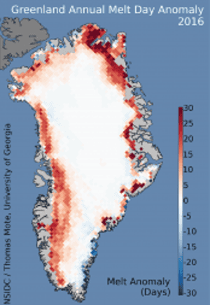
Increase in surface melting from Greenland. Illustration: National Snow and Ice Data Center
For ice-shelf collapse, there’s a complex process that occurs at the bottom of the ice. Part of the ice is floating out over water and part of it is grounded on land. Warm water can get underneath the ice, lift it up, and melt the ice from below.
The bedrock underneath the ice sheet is not flat or gradually changing. There are undulations that rise and fall and change the water-ice-ground connection. Topology called “retrograde” can make it easier for ice to melt and can increase the rate of ice shelf collapse. So, scientists have a real interest in learning about the topology of the land underneath ice sheets so they can better predict ice collapse and sea level rise.
This brings us to a new study published by the American Geophysical Union in a journal called Geophysical Letters Review. The scientists use gravitometry to obtain a high-quality picture of the land underneath a very fast moving part of Greenland ice called the Jacobshavn Isbrae. Basically, the scientists flew gravity sensors across the ice at low altitudes and low velocity. These sensors are called accelerometers and they can be used to determine the x, y, and z gravity components. The measurements of the gravity allowed them to attain the local height of the subsurface with greater accuracy than previously known.
As stated in the paper, the motivation for this work was clear:
the fjord bathymetry and glacier bed topography of the lower portion of Jacobshavn Isbrae have remained poorly known. At least not sufficiently to provide reliable information for ice sheet numerical models.
They found that the trough underneath the ice was not symmetrically shaped; the northern part of the trough was deeper than the southern part.


